Category: Tips for Cycling in Taiwan

  • Roadside Quick Fix Guide for Bicycles

    Roadside Quick Fix Guide for Bicycles

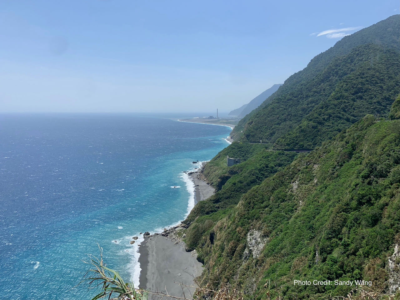
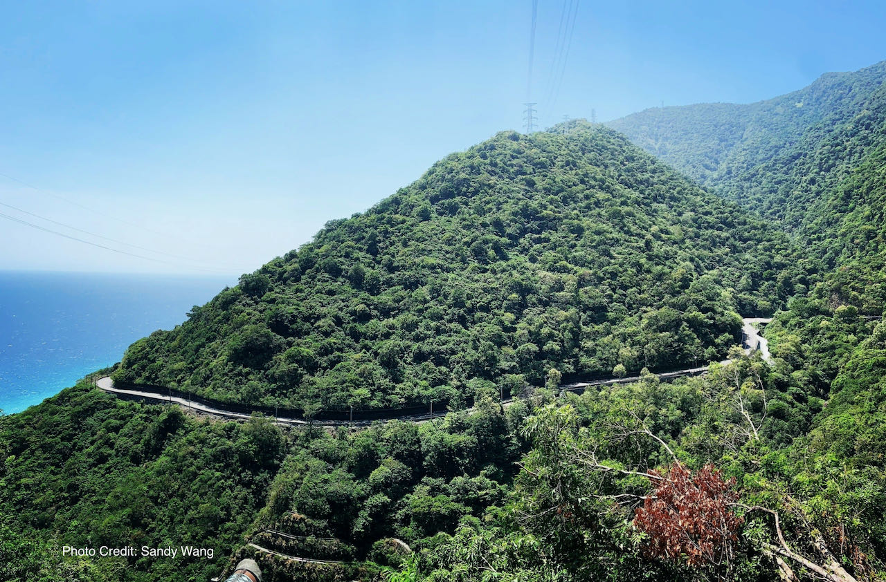
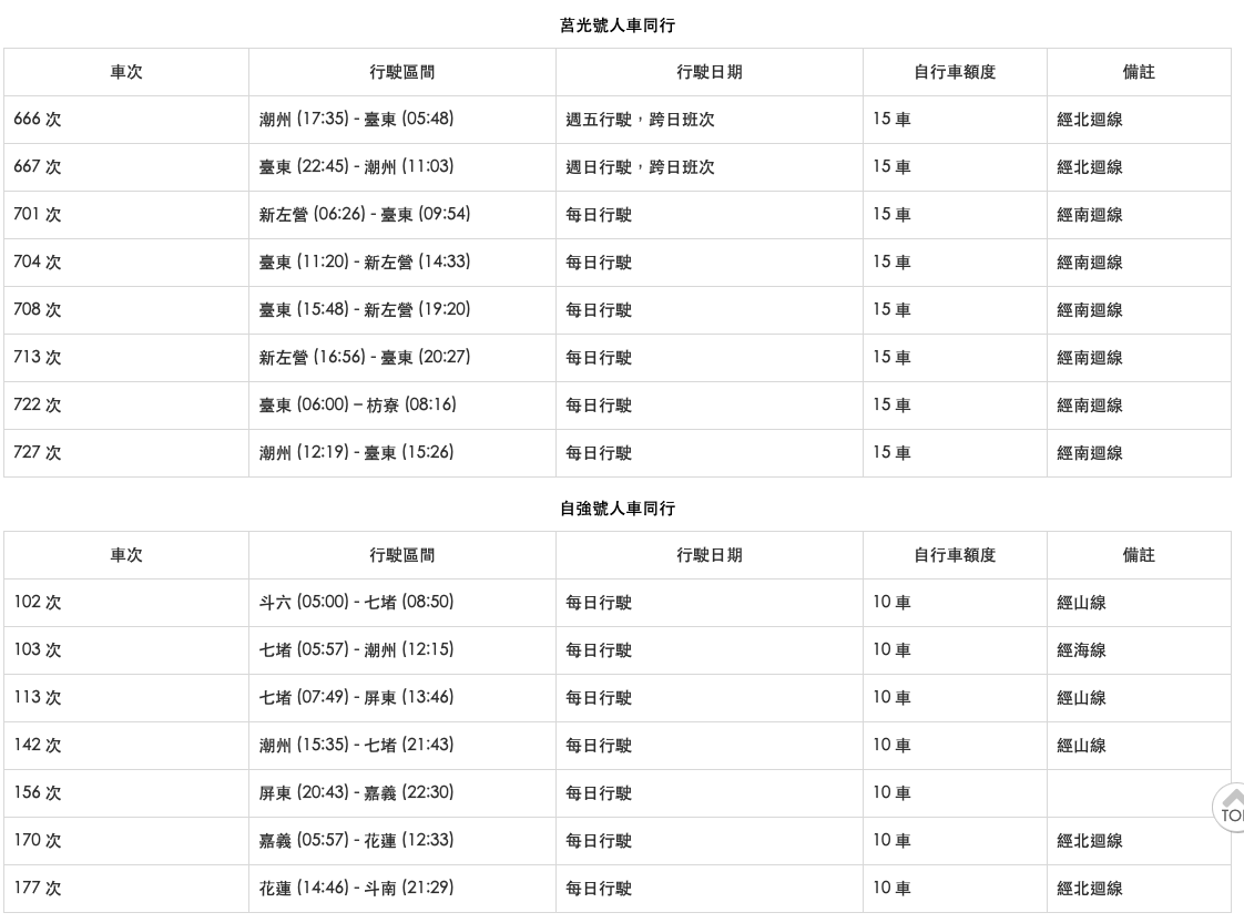
    This guide aims at helping our customers solve the most common mechanical issues that may occur during the cycling trip. 

    How to Adjust Saddle Height

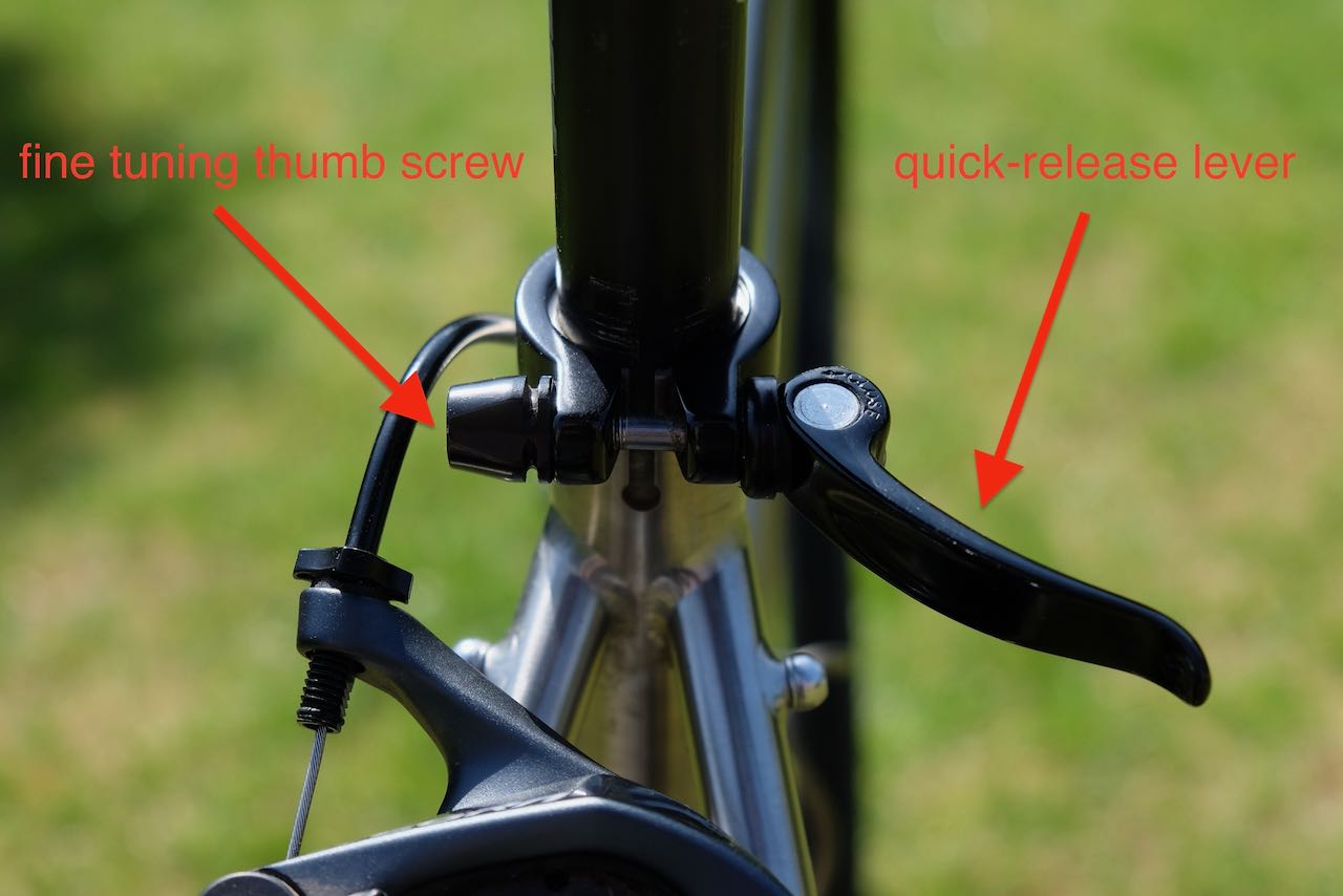
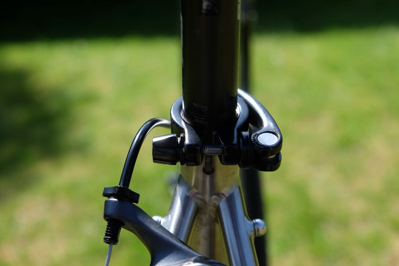
    Most of our bikes feature a quick-release seat post clamp for easy saddle height adjustments. To adjust the saddle, open the quick-release lever, move the saddle to your desired height, and then close the lever securely.

    If the saddle slips because the clamp doesn’t provide enough friction, use the thumb screw to fine-tune the tightness while the quick-release lever is open. However, if you can’t close the lever with bare hands after adjusting the thumb screw, the clamp is too tight. 

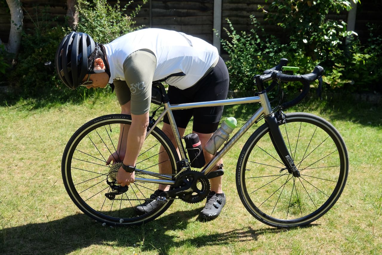
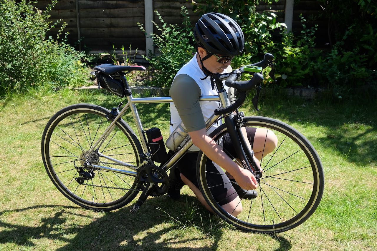
    How to Remove and Install Wheels

    You may need to remove your bike’s wheels for several reasons, such as bagging the bike for train or public transportation, fixing a flat tire, or replacing brake pads.

    Numerous YouTube videos, https://youtu.be/hdjB_wHW0-Q, provide clear instructions for removing and installing wheels on various types of bicycles.

    However, I’d like to share some practical tips to make the process smoother, especially when you’re working roadside.

    Quick-Release Skewers

    Quick-release skewers come in two types. The most common requires flipping a lever to clamp or unclamp the wheel at the dropouts. Newer designs involve turning the lever to loosen or tighten the skewer. Before removing a wheel, check whether the lever flips or turns.  

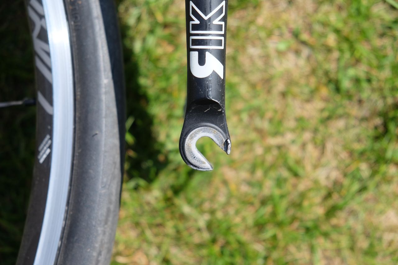
    Front dropouts often have retention tabs (sometimes called “lawyer lips”) to prevent accidental wheel release. To free the wheel, unscrew the skewer further (about six counterclockwise turns).

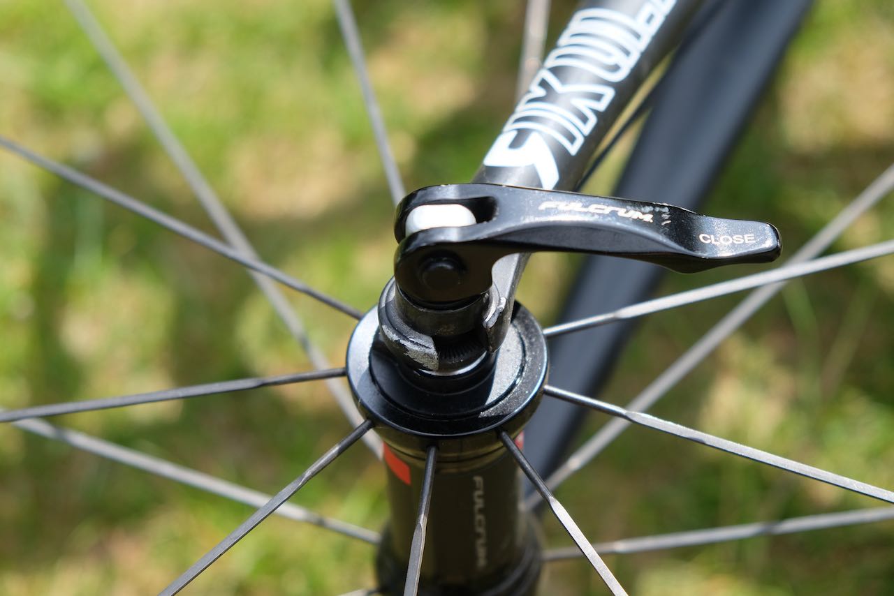
    When installing a wheel, ensure the skewer seat properly with both dropouts to prevent a tilted wheel. For the front wheel, stand the bike on a firm surface, press down on the top tube with your armpit, and secure the quick-release lever with your hands. For the rear wheel, apply gentle pressure with your torso against the saddle while locking the lever. For non-flipping levers, the angle of the levers can be adjusted by pulling out the levers.
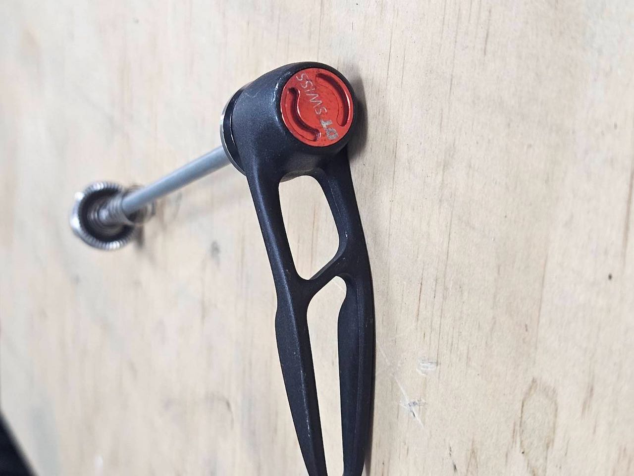
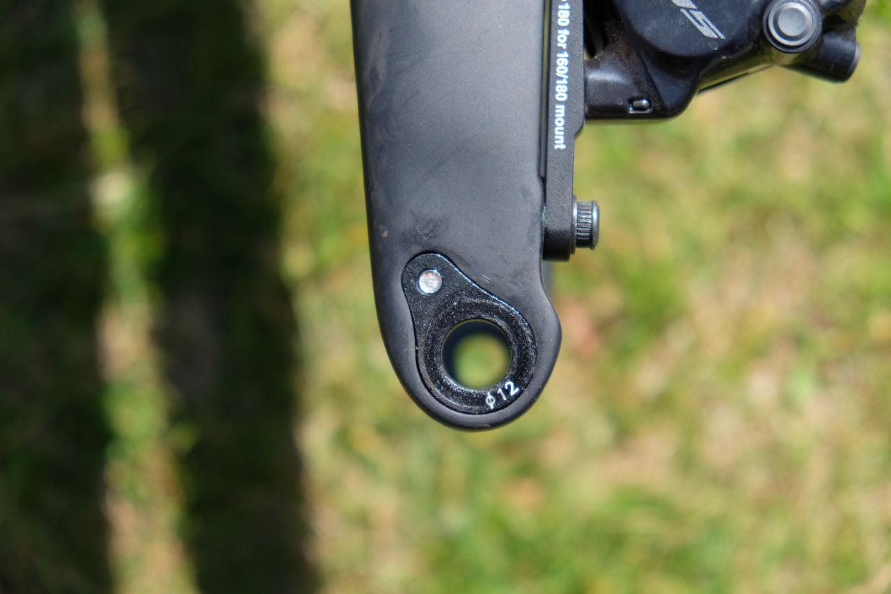
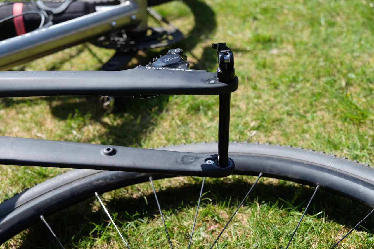
    Thru Axles

    Thru axles are common on bikes with disc brakes. Unlike quick-release systems, where the wheel and skewer drop out from the frame, thru axle systems require removing the entire axle from the frame to release the wheel.

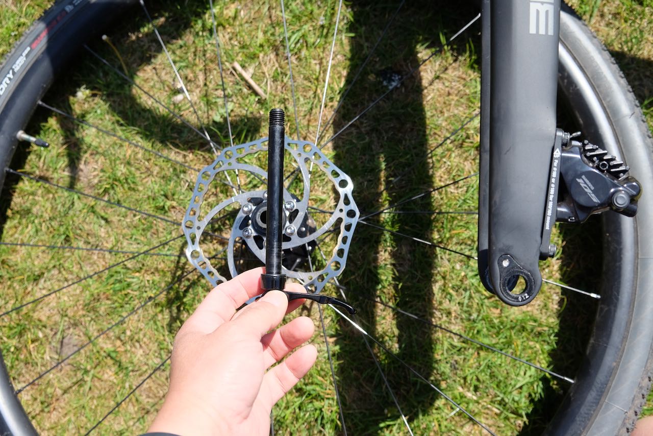
    After removing the wheel, reinsert the thru axle into the frame for safekeeping to avoid losing it. Avoid squeezing the brake lever when the wheel is off, as this can close the gap between the brake pads, making wheel reinstallation difficult. If transporting or storing the bike, insert a spacer between the brake pads to prevent this issue.

    When reinstalling the thru axle, avoid over tightening, as this can damage the axle or misalign the disc brake caliper, leading to brake pad rubbing and scraping or squealing noises.

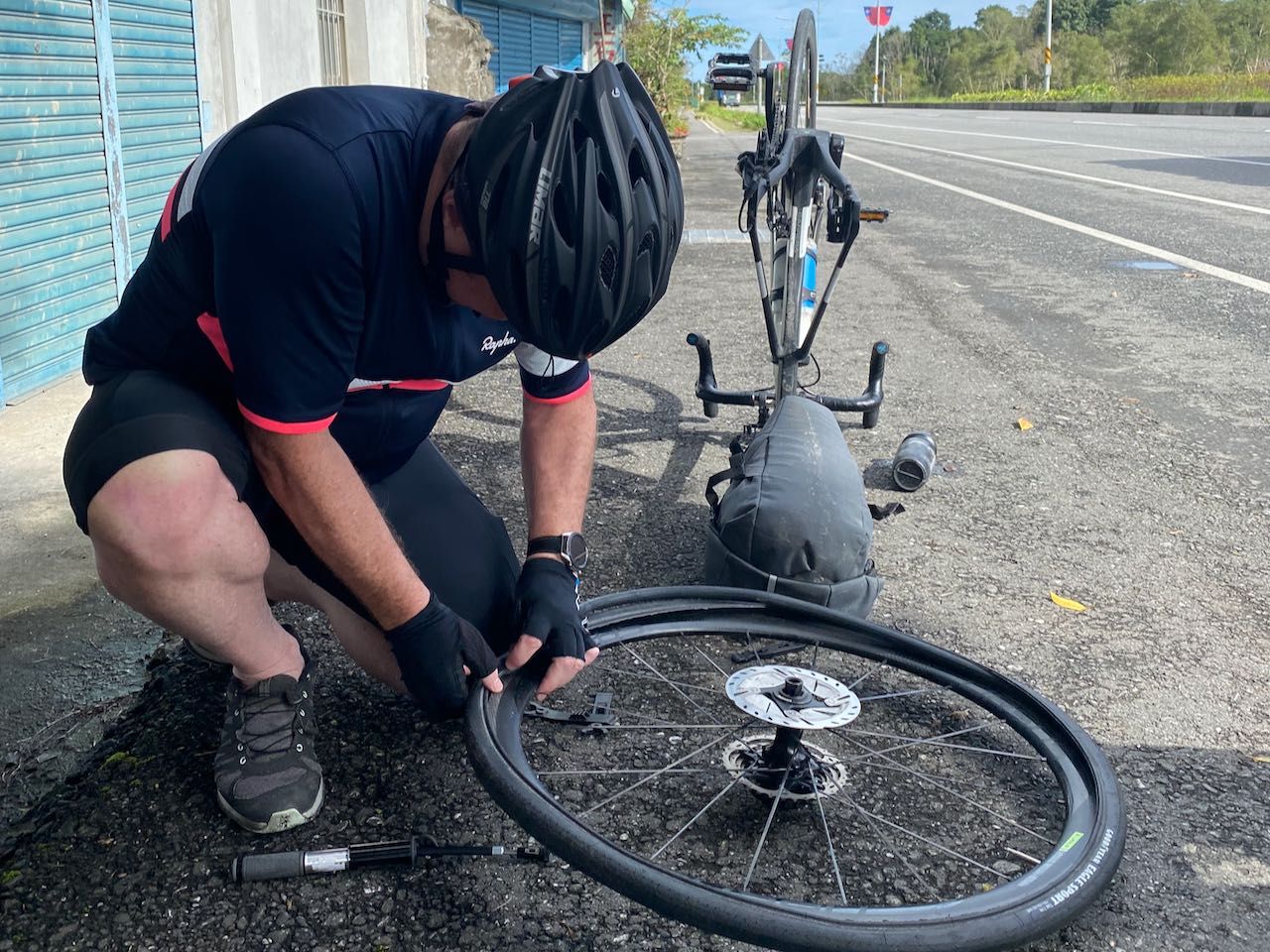
    How to Fix a Flat Tyre

    The fastest way to fix a flat tire is to replace the inner tube with a new one, included in our kit. Many YouTube videos, like this one https://www.youtube.com/watch?v=eqR6nlZNeU8, demonstrate the process clearly.

    Here, I’d like to highlight key tips to make the job easier, especially when you’re fixing a flat roadside:

    Preparation

    Choose a clean, safe spot with minimal stones, sand, or debris before starting. When replacing the inner tube, the tire is open and laid on the ground, allowing small sharp objects to get inside. If trapped between the tire and the new inner tube, these objects can pierce the tube when inflated, causing another flat.

    Removing the Inner Tube

    As shown in the video, you can remove the entire tire from the rim to replace the inner tube. However, it’s often quicker to remove just one side of the tire bead, leaving the other side on the rim, to swap out the tube.

    Finding the Cause of the Flat

    After removing the inner tube, identify what caused the flat to prevent a repeat issue.
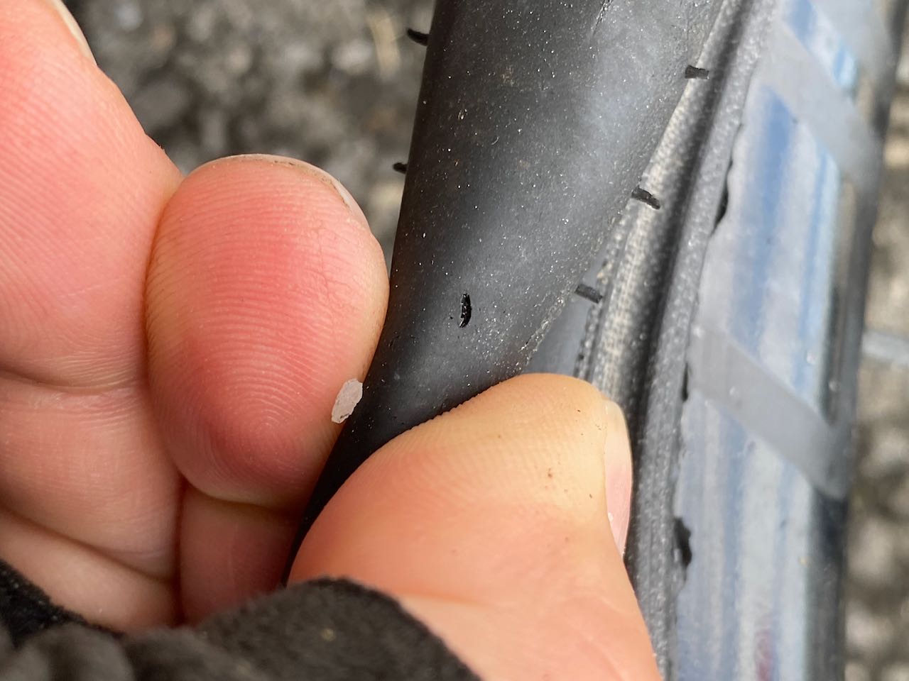
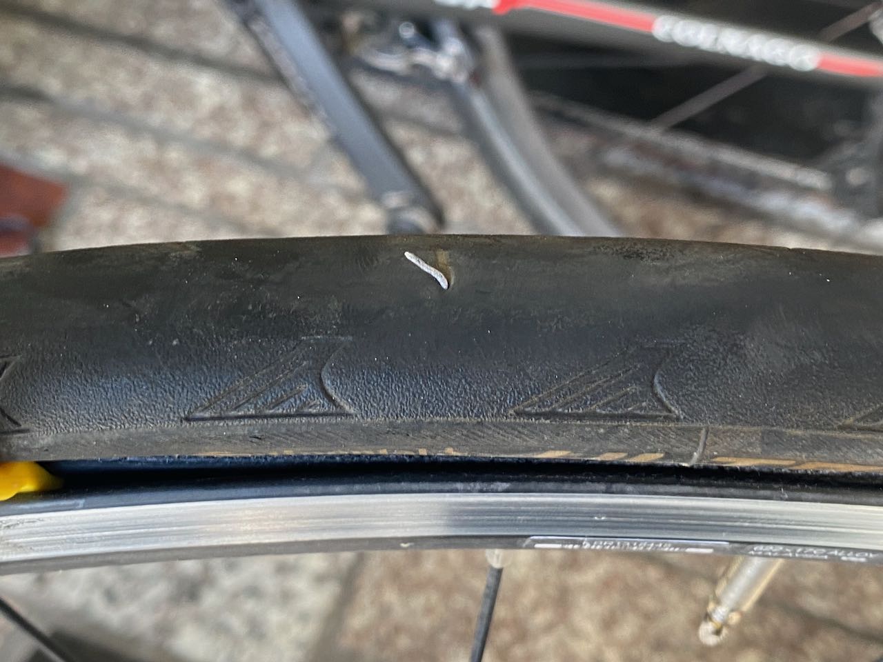
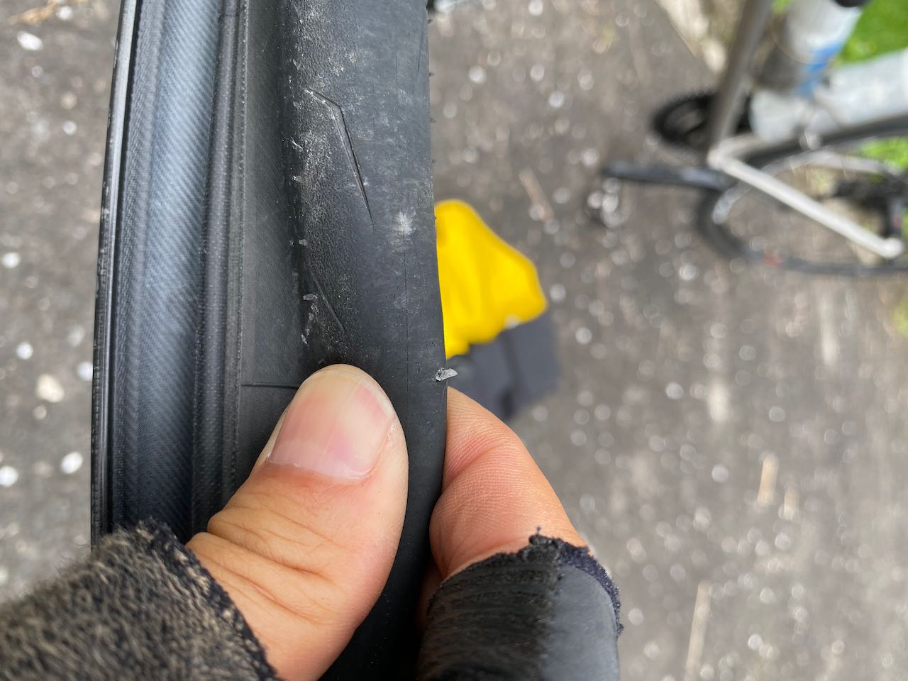
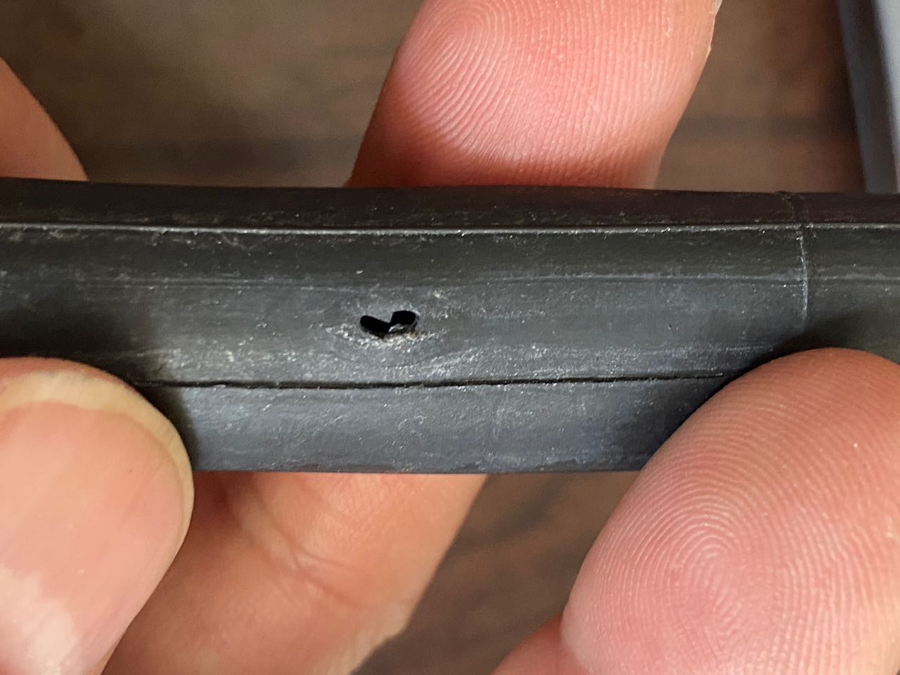
    Puncture

    A puncture occurs when a sharp object pierces the tire, creating a small hole in the inner tube. Always remove the sharp object before installing a new tube to avoid another flat. To locate it:

    • Find the hole in the inner tube.
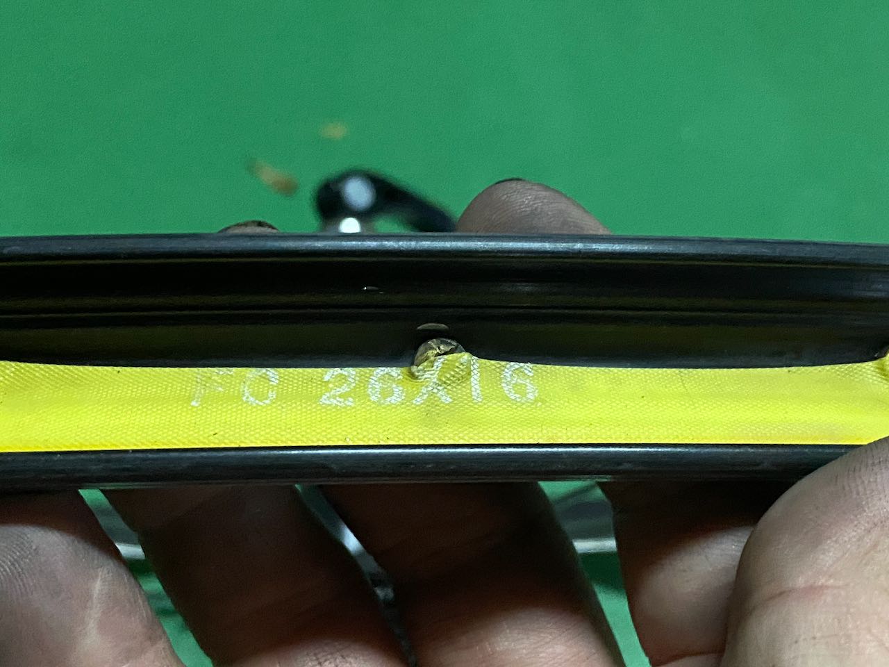
    • Align the inner tube with the tire, matching the valve to the valve hole, to narrow down the search area.
    • If you’ve removed the tire completely, align the valve with the tire’s label, as we typically position the label near the valve during installation.

    Once the sharp object is removed, the tire is usually reusable unless it has a large cut exposing the inner tube. (More about tire cuts in the next section.)
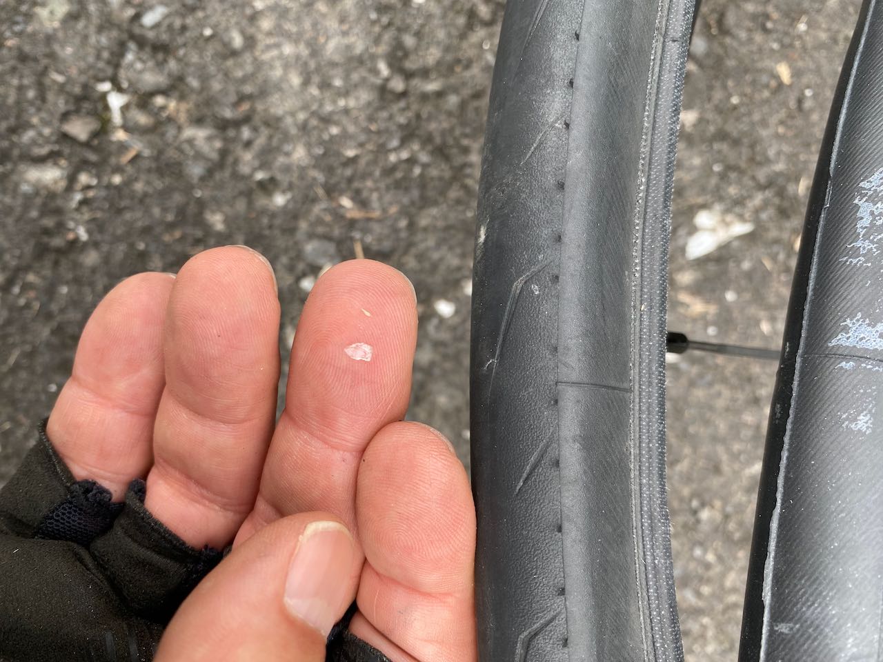
    Common Culprits

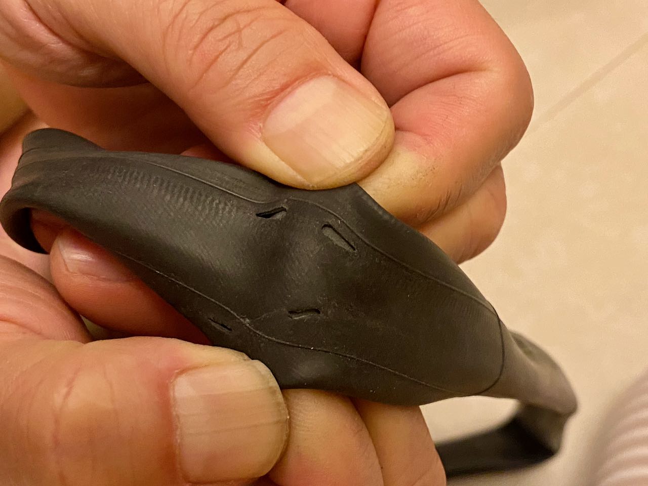
    Here are some of the pesky objects I’ve encountered that cause punctures:

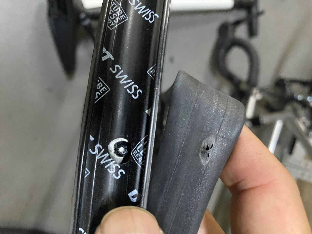
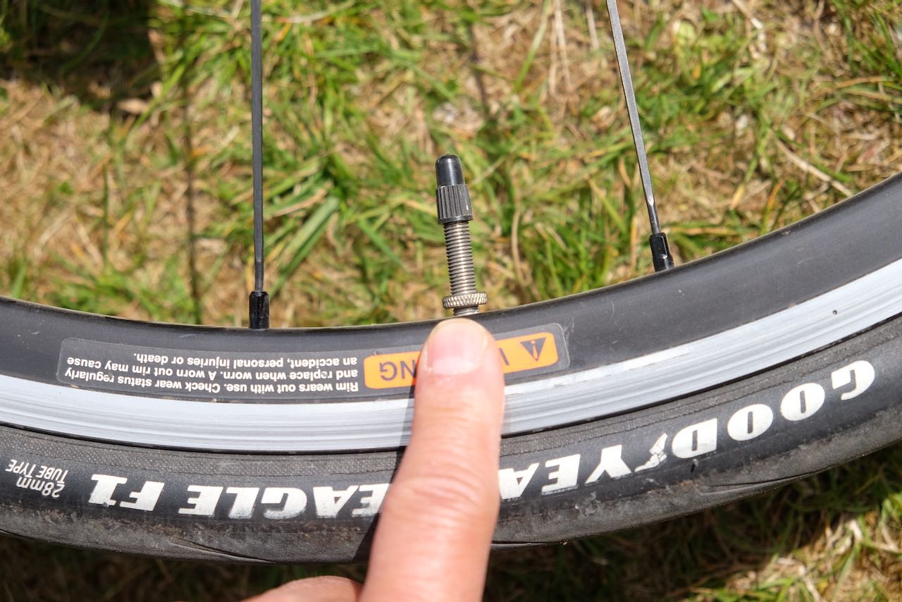
    Compromised Rim Strip

    A compromised rim strip is less common, but if you notice a large burst on the rim-facing side of the inner tube, check the rim strip. The rim strip is a protective fabric band wrapped around the rim to cover spoke holes, preventing the inner tube from expanding into them under high air pressure, which can cause a burst. It also shields the tube from sharp metal edges. A rim strip may fail if it doesn’t fully cover the spoke holes or becomes too worn to withstand pressure.

    To diagnose, use the burst in the inner tube to locate the compromised section of the rim strip by aligning the valve with the valve hole. In most cases, the rim strip needs replacement. For a temporary roadside fix, insert a folded banknote between the rim and the inner tube to cover the exposed spoke hole. Then, carefully ride to the nearest bike shop for a proper repair.

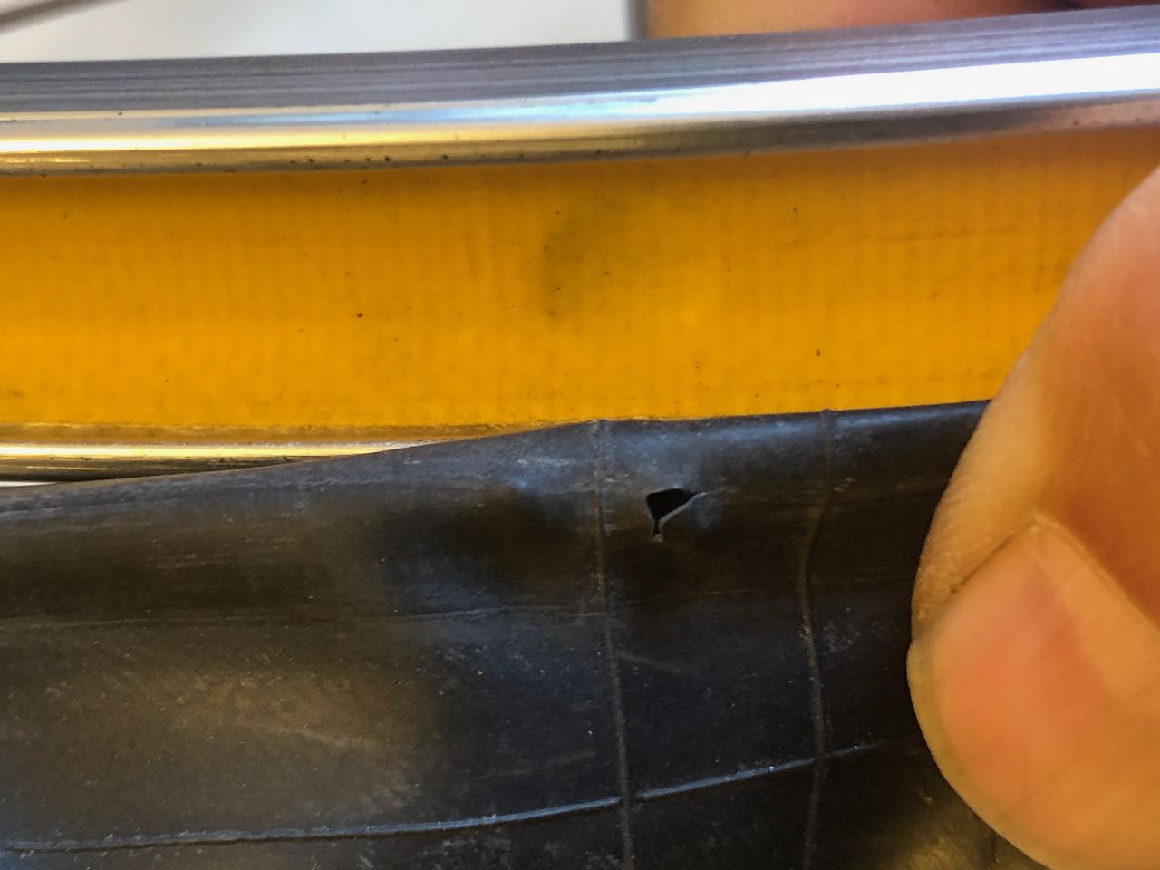
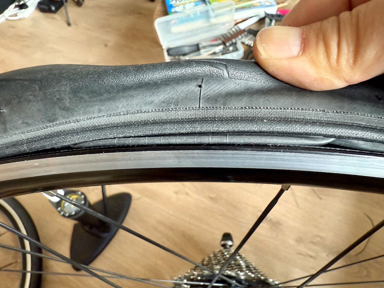
    Pinch Flat / Snake Bite

    A pair of holes on opposite sides of the inner tube is usually caused when the bike hits a pothole or a curb. The tube gets pinched between the rim and the tire, resulting in cuts that resemble a snake bite. Riding with insufficient tire pressure increases the risk of pinch flats. Check and top up your tire pressure every three days to reduce the risk.

    Installing the Inner Tube

    After installing the inner tube and moving the tire bead onto the rim, make sure all the  innertube is tucked inside the tire body by running a full circle of the wheel on both sides. If you see the innertube poking out, you need to tuck it in before proceeding to inflate the tire.
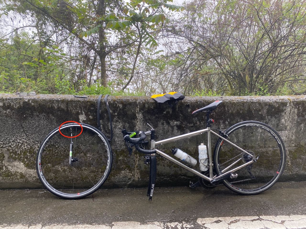
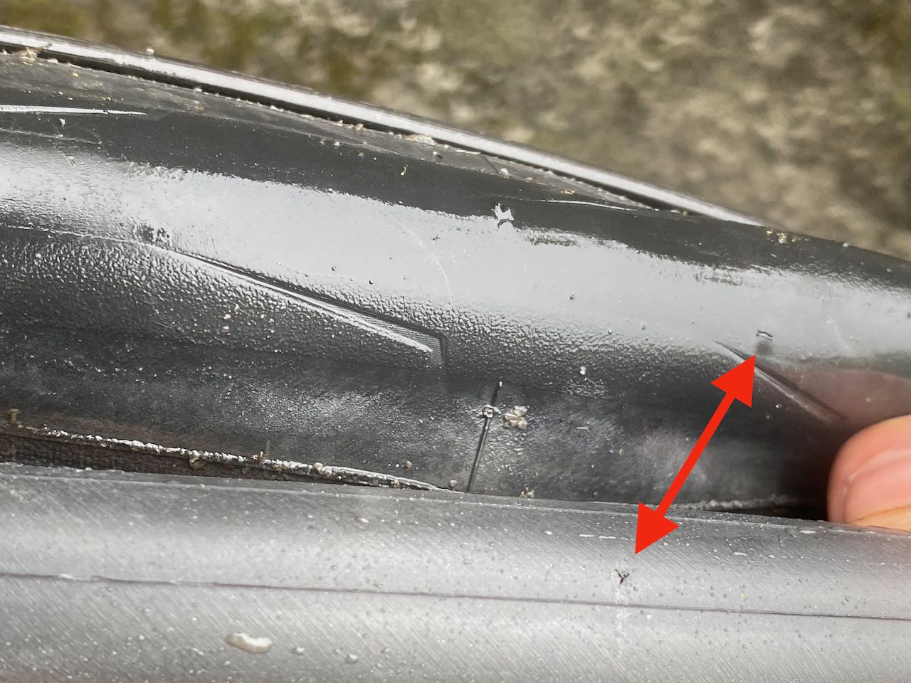
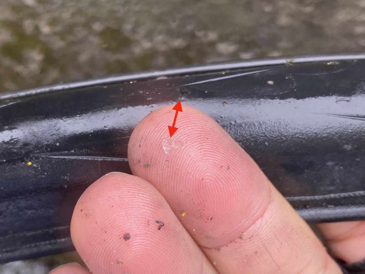
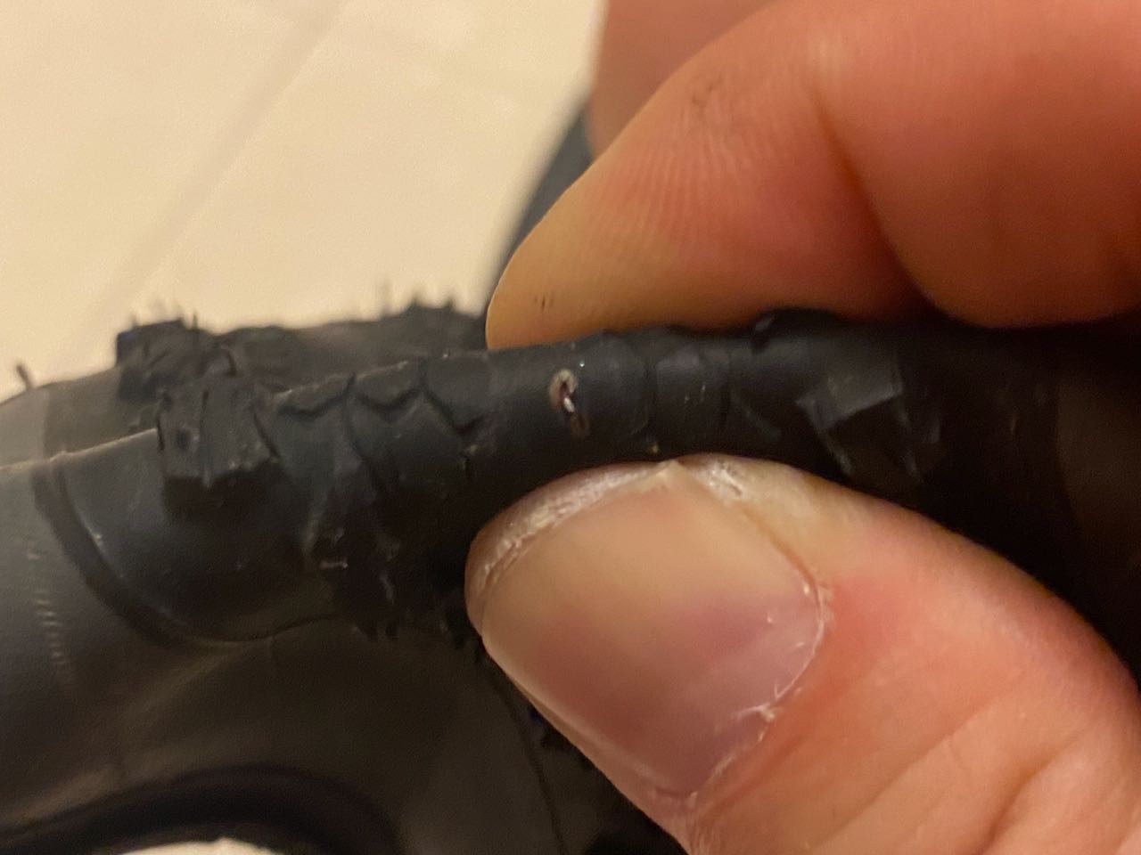
    Tires with Cuts

    A punctured tire can still be used after the inner tube is replaced. However, a tire with a cut that exposes the inner tube from the outside must be replaced. The exposed tube is vulnerable to the rough road surface and high internal pressure without the tire’s support, another burst is very likely.

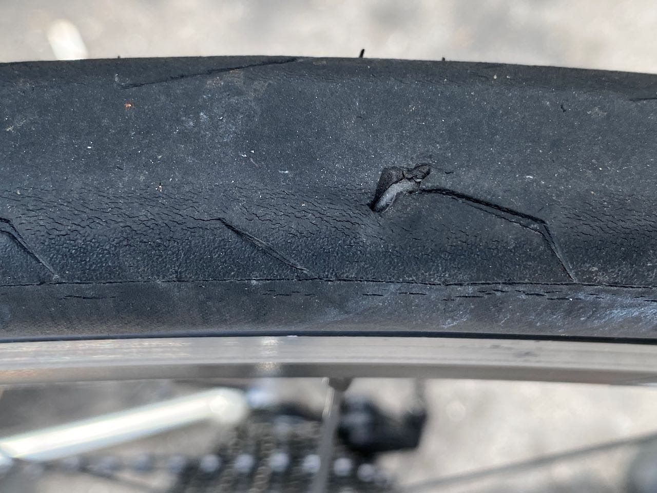
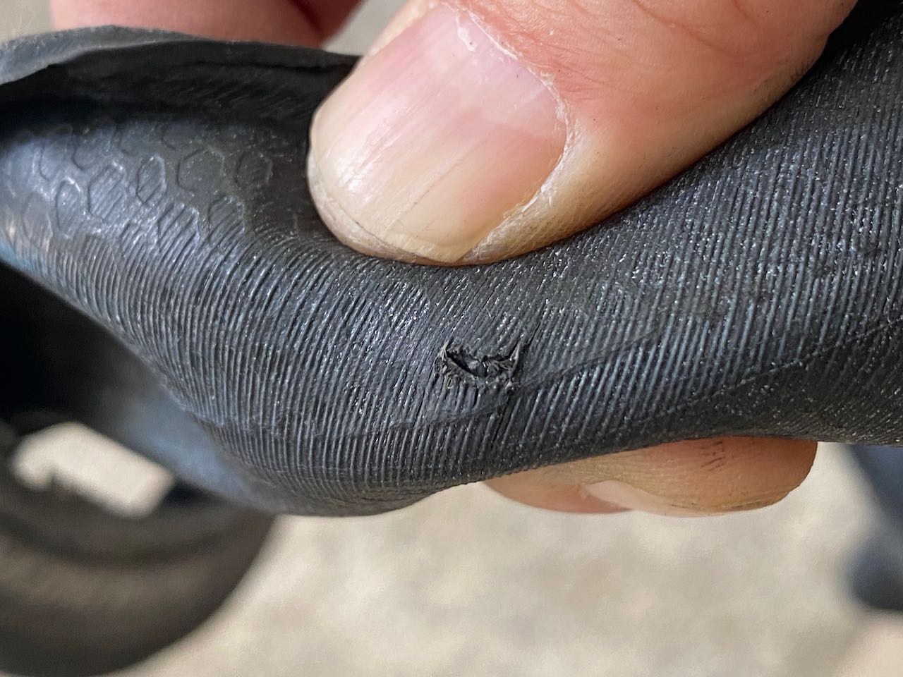
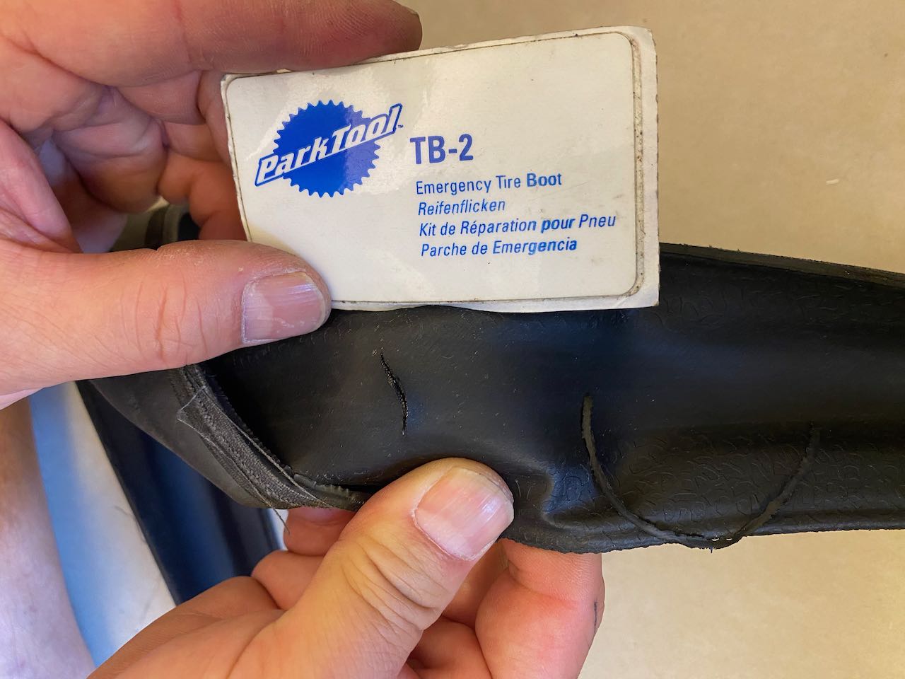
    For a temporary roadside fix, stick a tire boot (like a Park Tool TB-2) inside the tire to protect the tube. If you don’t have a tire boot, a folded bill (like a dollar bill) can work for a small cut. Then, carefully ride to the nearest bike shop to get a new tire.

    Unusual Noises

    Bikes can make all sorts of sounds, but unusual noises often point to simple fixes you can handle on the go. Here’s how to diagnose and resolve common noises you might hear while cycling:

    Rattling Noises

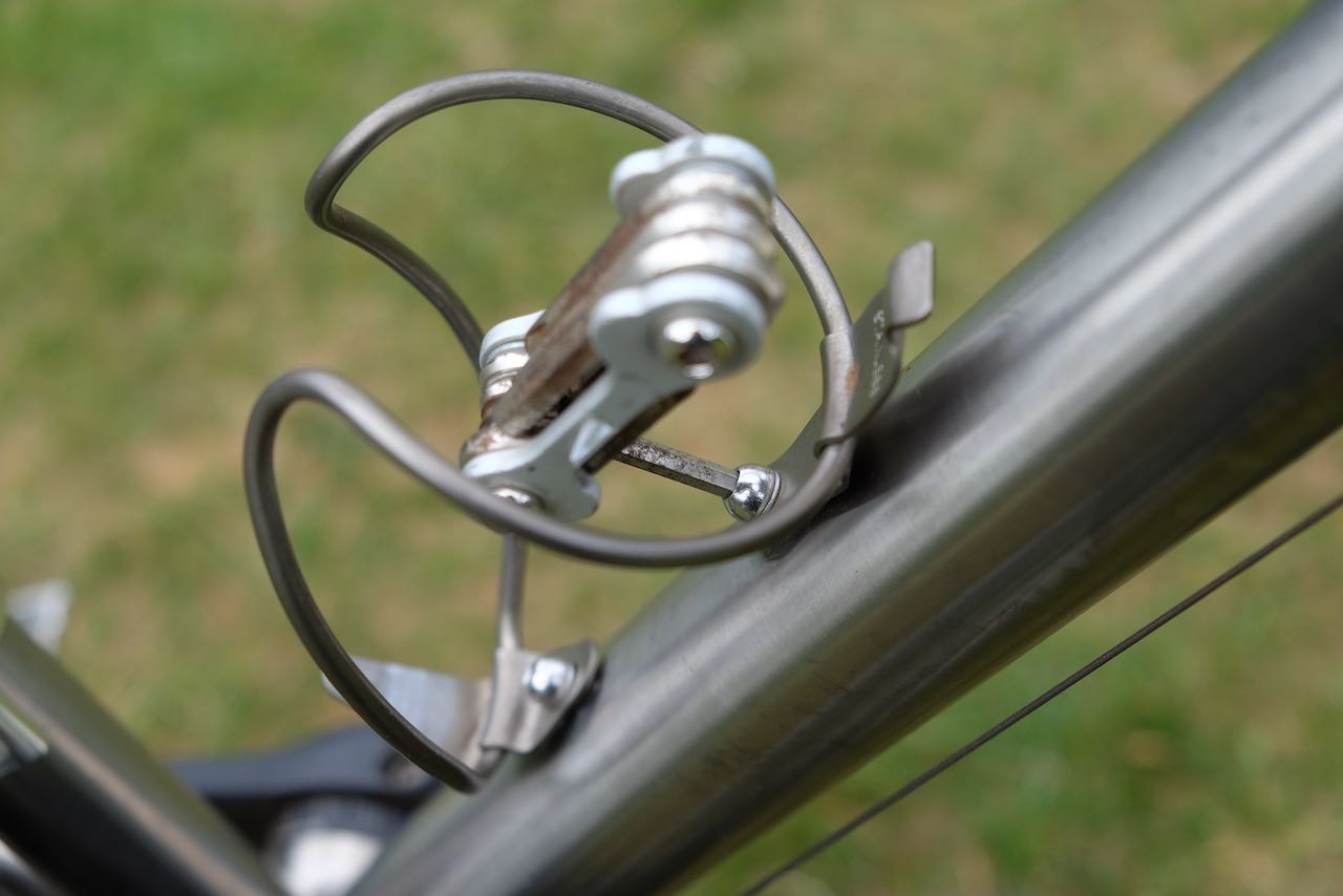
    Rattling noises often come from loose components. Check the bolts on your water bottle cage or pannier rack, as these can loosen over time and cause rattling. Use a hex key to tighten them—hand-tight is enough to secure them without overdoing it.

    Another culprit could be a loose valve core lock ring on the inner tube. This ring, which secures the valve core, can vibrate and make noise if not tight. Gently tighten it by hand, but be careful: overtightening can damage or tear out the valve core.

    Noises Related to Bike Speed

    If you hear noises that change pitch with your speed, loose straps or covers on pannier bags might be the issue. These can flap against the spokes or rub against the tire, creating a sound that gets higher-pitched as you ride faster. Inspect your pannier bags and secure any loose straps or covers to stop the noise.

    Noises Related to Pedal Cycle

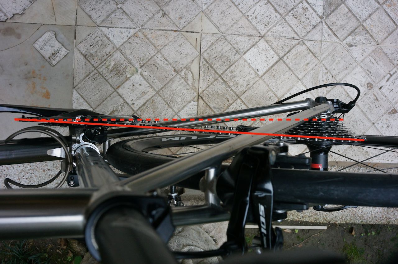
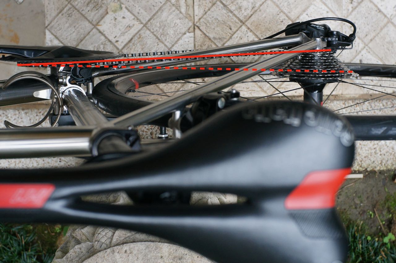
    Noises that sync with your pedaling often indicate a drivetrain issue. Check if the chain is rubbing against the front derailleur while pedaling, which can happen with cross-chaining—using inefficient gear combinations like the big chainring (front) with the two largest cogs (rear) or the small chainring with the smallest cogs.

    Cross-chaining strains the chain, increases component wear, and causes noise.

    To fix this, shift to a better gear combination to avoid cross-chaining. For Shimano road bike groupsets, use the trim function on the front shifter to slightly adjust the front derailleur’s position when moving to larger rear cogs. As you shift to bigger cogs at the rear, the chain moves inward, and trimming moves the derailleur slightly inward without changing the chainring, preventing rubbing. Personally, I avoid using the two largest rear cogs when on the big chainring to minimize wear and noise.

    Conclusion

    With these tips, you’re equipped to handle flat tires, especially to avoid repeated flat tires, and pesky bike noises, keeping your cycling adventures smooth and enjoyable. Regular maintenance and quick fixes like these can make all the difference on the road.

  • Cycling Through Taiwan: A Seasonal Weather Guide

    Cycling Through Taiwan: A Seasonal Weather Guide

    I often receive customers asking about the weather in Taiwan. Here I would like to share with you a brief idea of the climate of the island.

    Quick Facts

    CategoryDetails
    Temperature– Annual average: 24°C (South), 22°C (North)
    – Warmest: July (average 27°C)
    – Coolest: February (15°C North, 19°C South)
    – Temperature decreases in higher altitudes.
    Winter– Short, mild, rarely below 10°C at sea level
    – Ideal for cycling
    – Few days exceed 30°C in late autumn to early spring
    Summer– Hot, especially at noon (risk of heat stroke)
    – Best to start cycling early in the morning, before sunrise
    Precipitation– Annual average: 6,700mm
    – Mostly brought by typhoons
    – More rain in mountains, east coast, and windward sides
    – Winter: North drizzly, South dry
    – Summer: South rains more, with 1–2 hr thunderstorms
    – 3.5 typhoons/year (June–October)
    Sunshine– Summer: 5:00–18:45
    – Winter: 6:30–17:00
    – Navigation can be tricky when it gets dark
    – Use sunblock even on cloudy days
    Wind– October–April: Strong northeast monsoons
    – Hengchun Peninsula: Beware of downhill winds
    – May–September: Southwestern monsoon, lighter winds

    Information source: http://twgeog.ntnugeog.org/en/climatology/

    Weather in Taiwan During Cycling Seasons

    Since most people visit Taiwan for cycling between September and April, here is detailed description of the weather based on data from the Central Weather Administration (1991-2020) and my personal experience in Taiwan. 

    Temperature

    The entire island remains hot in September. Data from 1991-2020 indicates around 20 days with maximum temperature exceeding 30℃ (hereafter referred to as “hot days”), except in higher-altitude areas like Sun Moon Lake, which only experiences 2 hot days. Locals refer to this lingering heat as the “Autumn Tiger” – the heat bikes.

    In October, the northern part of the island cools significantly, with about 6 hot days. However, the south remains warm, feeling like summer with 12-20 hot days. 

    As the winter sets in during November, hot days become rare, lasting until April when the southern region sees around 12 hot days, and the northern region fewer than 10. The average temperature across the island ranges from 16℃ to 25℃, except in high-altitude areas.

    Precipitation

    Typhoons may still affect Taiwan in September and October, bringing heavy rains that could disrupt travel plans. If you’re visiting during this period, keep an eye on Pacific typhoon activity. 

    From November to April, Taipei experiences 12 -15 rainy days per month (defined as days with over 0.1mm of precipitation). Most of these are light drizzles caused by prevailing northeast winds, making cycling still manageable due to the mild temperatures.

    Cycling southward from Taipei on an anti-clockwise route, the likelihood of rain decreases. Cities like Hsinchu, Taichung, and southern regions on the west coast have 3-9 rainy days per month, depending on the location. On the east coast, rainfall increases as it’s the windward side of the mountains. Dawu and Taitung see around 10 rainy days monthly. Further north, Su’ao and Yilan experience 18-20 wet days. So, you are cycling back to the wet zone as you head north. Prepare for wet conditions on the way back to Taipei.

    Wind

    Wind is a crucial factor when planning a cycling itinerary.

    Using the Bike Calculator, a cyclist weighing 70 km requires 70 watts of power to maintain a speed of 20km/h on a flat road. It takes 5 hours to cover a 100 km ride.However, with a 5m/s (18km/h) headwind, the speed drops to 11.7km/h, extending a 100 km ride to 8.5 hours. Conversely, a 5 m/s tailwind boosts speed to 30 km/h, reducing travel time to 3.33 hours.

    Average wind speeds in Taiwan range from 2m/s to 6m/s, but during the northeast wind season, speeds often exceed 5m/s. Following our anti-clockwise Classic 9-Day Cycling Around Taiwan Itinerary, you’ll benefit from tailwinds on the west side of the island by travelling southwards. As the west is more populous, you may follow the routes on this post – Speed Up on the West Coast to avoid the traffic lights for thrilling speed rides.

    As you climb over Shouka and descend to the east coast, headwinds become challenging. Day 5 (Pingtung County to Taitung County)  is particularly tough during the northeast wind season. After climbing a 500-metre hill, you will find yourself cycling along cliffs exposed to the Pacific Ocean, with endless, unobstructed fresh headwinds blowing in your face. Splitting this stretch into two days is advisable, as it not online allows riders more time to combat the wind but also to savour the scenic beauty.

    In Taitung, the Rift Valley provides some wind protection, with the southern section being the most picturesque. It is preferable to stay there. But if you had not enough of the sea, consider switching to Provincial Highway 11 on Provincial Highway 30 from Yuli, on 花64 (Ruigang Industrial Road) Ruisui or on Provincial Highway 11甲 (11A)  Guangfu.  “ 花64 or Ruigang Industrial Road from Ruisui to Fengbin is the most interesting route, Provincial Highway 30 from Yuili to Ningpu is the 2nd best and Provincial Highway 11A or 11甲 is good for a passage”, said Eddie Chen, the cyclist Youtuber.

    Upon reaching Yilan, prevailing winds continue to push aghast us. However,  cycling anti-clockwise means you’ll avoid the harsher headwinds of the west side, according to Eddie Chen’s experience. After turning northwest at Sandiaojiao, we’ll once again have a tailwind to propel us back to Taipei, completing the loop.

    Tips for Cycling in Taiwan During Summer

    While summer in Taiwan is often considered too hot for cycling, some enthusiasts still complete the loop. Here are some tips if you plan to ride during this season:

    Hand-pick Your Routes

    Choose shaded routes to escape the sun. Temperatures are cooler at higher altitudes, with areas like Sun Moon lake and Alishan rarely experiencing days over 30°C in July and August. If you like climbing, you may stay in the mountains by following the routes in these two posts – Slit the Sweet Potato – Cycle Through Taiwan’s Mountainous Splendor, part 1 and part 2.

    Recommended Daily Schedules

    Start early, before sunrise, to avoid the heat. Take long lunch breaks or schedule indoor activities during midday. Frequent stop at air-conditioned convenience stores can help you cool down.

    Stay Hydrated

    Drink water or electrolyte drinks regularly to combat dehydration caused by heat and humidity. Ice, available at convenience stores at the same price of a bottled water, can help keep your drinks cool.

    Wear Appropriate Clothing

    Wear lightweight, breathable, and UV-protective clothing such as Lycra or polyester. These materials wick sweat away, keeping you cool while protecting your skin from sunburn. Avoid cotton, which traps moisture and increases discomfort.

    Sunscreen is a Must

    Apply sunscreen 20-30 minutes before heading out and reapply every two hours. Use SPF lip balm and wear a tube scarf to shield your lips and neck.

    Beware of Heat Exhaustion

    Be alert for signs of heat exhaustion, including cool moist skin, heavy sweating, dizziness, or fatigue. If symptoms occur, stop cycling, rest in a cool place, and hydrate. Seek medical attention if necessary.

    Conclusion

    Cycling in Taiwan offers an unparalleled experience for riders, blending scenic landscapes with diverse weather conditions. Whether you’re navigating the autumn heat, cruising with tailwinds in winter, or tackling summer challenges, careful planning ensures a memorable journey. Embrace the unique beauty of Taiwan’s seasons and discover the joy of cycling through its captivating landscapes.

  • Road Conditions for Cycling in Taiwan – How to Check the Latest Information

    Road Conditions for Cycling in Taiwan – How to Check the Latest Information

    The roads in Taiwan are exceptionally well-maintained. In cases where damages are caused by earthquakes and typhoons, repairs are swiftly carried out, ensuring that roads, including those for cycling around the islands, are quickly restored. However, in some remote areas, such as the mountains, road repairs can be more challenging and may take longer.

    During the repair period, some roads may be temporarily closed, while others may allow passage only during specific windows of time, potentially interrupting our rides. To ensure smooth cycling through these areas, it is crucial to check the website of the Highway Bureau MOTC, which provides a ‘Provincial Highway Real-time Information Service.’

    • Click on the “Switch Language” at the top right corner to change the interface to English
    • Click on “Prov. Highway CCTV” to deselect it. Then, click on “Construction Info.” and “Disaster Info.” to select them.
    • On the map, zoom in to the area you plan to visit
    • Click on the icons on the map to view the text
    • Select the text, copy it, and then Paste to computer translation services like Google Translate or ChatGPT

    At times, traffic control information can be found in ‘Construction Info.’ while at other times in ‘Disaster Info.’ Therefore, it’s important to read information from both categories. Please do not blame the translation services if you find it hard to understand. The original text may pose challenges even for a Chinese-speaking person, and occasionally, I find it necessary to call the nearby police station to confirm my understanding.

    It’s crucial to note that this website only displays road conditions for Provincial Highways. In instances where we prefer cycling on County Highways, Township Roads, and Industrial Roads, for quieter traffic and better views, I have yet to find a centralised website for that. In such cases, searching for news about a particular road or calling nearby police stations to check becomes essential. Additionally, when booking hotels or restaurants, staff members may provide valuable information about any road closures. In case of poor road conditions, it’s safer to switch to larger roads.

  • Cycling the Suhua Highway: Evaluating Challenges, Experiences, and Factors to Consider

    Cycling the Suhua Highway: Evaluating Challenges, Experiences, and Factors to Consider

    Farewell to the section of Daqingshui to Horen (Provincial Highway 9D 64K to 69K)

    The 403 Earthquake in 2024 and the subsequent typhoons brought severe damage to the 5km section of Provincial Highway 9D (9丁) between Daqingshui (大清水) and Horen 和仁. The government announced in January 2026 that they won’t be repairing this section (Provincial Highway 9D 64K to 69K) anymore. all traffic is now redirected through Provincial Highway 9 between Daqingshui and Horen.

    To avoid the heavy traffic on Provincial Highway 9 and cycle only on Provincial Highway 9D, you may take a train to Heping Station, cycle to Nan’ao Station, and then take a train to Dong’ao Station to resume cycling from there.

    The Suhua Highway is a treacherous and narrow roadway that winds along the edge of a steep cliff, connecting Hualien to Yilan. It navigates through hilly terrain, featuring three major climbs and noisy tunnels. Cycling on this route is considerably more challenging compared to other sections of Cycle Route No. 1. As a result, it is often recommended to take the train with our bikes to bypass this segment.

    However, cycling on Suhua Highway offers stunning coastal views, challenging terrain, a sense of adventure, and a refreshing experience in nature. Some cyclists embrace the opportunity for the breathtaking views and the exhilarating experience of tackling the challenging terrain.

    We had customers wondering if they should do it. Here are my thoughts about whether to cycle on this part.

    Challenging: long with lots of climbing

    The Suhua Highway from Xincheng to Su’aoxin is not an easy one. We have 82 km to cover with several peaks to climb, resulting in a total ascent of 1,675m according to Garmin Connect. We need to estimate our strength and decide how challenging we want our day to be.

    Risks posed by Mother Nature

    There are also some risks involved in cycling on this route. First, the risk posed by mother nature. Landslides and falling rocks on the road, though not common, can occur, particularly after earthquakes, heavy rains, and typhoons.

    Risk posed by other vehicles

    Secondly, there is a risk posed by other road users such as heavy trucks, coaches, and cars. The road is narrow, leaving less space for those vehicles to overtake bicycles.

    Another challenge is cycling through the tunnels with those vehicles. Along the route, there are several narrow tunnels where the noises produced by heavy vehicles can be trapped inside, making it unpleasant to the ears.

    New Suhua Highway 

    The situation has improved after the Directorate General of Highways finished building the new Suhua Highway (Provincial Highway 9) in 2021. The new highway has diverted more traffic from the old one (Provincial Highway 9丁), making some of the sections more like a road exclusively for bikes. Which are shown on the map below in blue:

    • Daqingshui to Hezhong: 10.7km, Total Ascent 252m
    • Heping to Nanao: 25.9km, Total Ascent 453m
    • Dongao to Suaoxing: 18.84km, Total Ascent 420m

    Sections with Combined Traffics

    However, there are still some sections where the two highways merge and the traffic combine (shown on the map above in red). These sections are:

    • Xincheng to Daqinshui: 12.66km, Total Ascent 323m with 4 tunnels
      • 崇德隧道 (Chongde Tunnel): Length 325m, Width 7.5m
      • 匯德隧道 (Huide Tunnel): Length 1460m, Width 7.5m
      • 錦文隧道 (Jinwen Tunnel): Length 406m
      • 大清水隧道 (Daqingshui Tunnel): Length 521m, Width 7.5m
    • Hezhong to Heping: 3.63km, Total Ascent 24m
    • Nanao to Dongao: 10.94km, Total Ascent 275m with 1 tunnel
      • 新澳隧道 (Xinao Tunnel): Length 1267m, Two pipes (northbound pipe has two lanes)

    Update on January 2026: Since the Provincial Highway 9D between Daqinshui to Horen Station is severely damaged and there is no plan to repair it, the Overlapping Sections from Xincheng to Daqinshui is extended to Horen Station. The total distance from Xincheng to Horen Station is 15.6km, Total Ascent Estimated 300m (Data shown on Garmin route is exaggerated because the software failed to recognise the tunnel).

    Strategies and Tips

    If you are well-informed and decide to cycle on this part, here are some tips I would like to share with you:

    Cycle Only in Favorable Weather

    • Riding in poor weather conditions is both risky and unpleasant. Always choose to cycle when the weather is clear and stable.

    Be Mindful of Heavy Trucks

    • Although heavy trucks can be loud, their drivers are experienced and familiar with the route. They usually wait patiently for a safe opportunity to overtake cyclists. To make it easier for them, it’s best to ride in pairs rather than forming a long line, which can make overtaking more difficult.

    Cycling Northwards Is More Advantageous

    • Traveling northward (anti-clockwise around the island) offers several benefits. Most attractions are located on the sea side, and since Taiwan follows right-hand traffic, this direction allows for better coastal views without needing to cross the road. Additionally, it’s easier to spot falling rocks on this side.

    Plan Your Ride Timing Carefully

    • For Northbound Riders: Start early to pass through the four tunnels between Chongde and Daqingshui before traffic builds up. Beyond Daqingshui, most tunnels are located along the Old Suhua Highway (9丁 or 9D), where traffic is lighter. The final shared section of the new and old routes, from Nanao to Dongao, spans 11 km with a total ascent of 275 m and a 1.2 km tunnel. Assess your stamina, traffic conditions, weather, and time of day. If needed, you can take a train without bagging your bike to Dongao or Suaoxin.
    • For Southbound Riders: Start early to get through the Nanao–Dongao section before traffic increases.

    Use the Truck Drivers’ Lunch Break to Your Advantage

    • Between 12:00 and 1:00 pm, most truck drivers take their lunch break, leading to lighter traffic. Utilize this window to cycle through the busier sections more safely.

    Take the Train to Skip the Busy Sections

    If you only want to cycle on the best part of Suhua Highway (Provincial Highway 9D)  and skip those sections with heavy traffics, you can take a train from Xincheng Taoroko Station to Heping Station and then enjoy the  ride to Nan’ao Station on Provincial Highway  9D. Then take a train to Dong’ao Station and then ride all the way to Su’ao on Provincial Highway  9D. There are plenty of trains that allow you to push the bikes onboard after buying a ticket for your bike at half the adult fare. You can learn more about this from our blogpost on How to Ride with Your Bike on Public Transportation in Taiwan.

    Experience sharing from our customer

    Kevin, who did the around-the-island in September 2023, rode the Suhua Highway. He set off at 5:00 am from Xincheng and found the overlapping sections in Chongde very manageable in the early morning. When he reached Nan’ao around 10:00 am, there were heavy trucks. He said the heavy trucks usually came in waves. His strategy was to stop at the roadside to give way to the trucks first. Then he would have a window of about 10 minutes or so without the trucks. It would be long enough to cover a tunnel.

    During the Lunar New Year in 2026, JM and co. cycled north from Nan’ao and enjoyed favourable weather. They reported that the section from Nan’ao to Dong’ao was safe and wide enough for cycling, likely due to a reduced number of heavy trucks during the holiday. Furthermore, the route from Dong’ao to Su’ao was described as an “absolute dream for a cycler,” potentially ranking among the top ten cycling roads globally.

    Route – Xincheng (Taroko) Station to Su’aoxin Station

  • How to Prepare Your Garmin Device for Navigation in Taiwan

    How to Prepare Your Garmin Device for Navigation in Taiwan

    If you have the latest models of the Edge series, including 1050, 1040 or 840, and the latest firmware, you will be able to download a map of your choice directly to the device, without needing a computer. You only have to follow the procedures in this post if you have older models.

    Garmin devices are preloaded only with maps of your country. If you plan to use your Garmin device for navigation overseas, you will need to load the maps of the foreign country onto your device beforehand. Otherwise, you will only see a blank screen or a single line on your display.

    According to this web page of Garmin, if you own one of the Edge® 540/840/1040 Series devices, you don’t need to purchase maps separately. You can utilize Garmin Express, a computer software tool, to perform free map swaps and load them onto your device.

    For other series, purchasing the map at USD 19.99 is required. However, even if you are willing to pay for the map, you might not find the map of Taiwan available for purchase on Garmin’s website. Thankfully, there are alternatives: OpenStreetMap and BBBike Extract Services. The process is straightforward. Simply visit this website, https://garmin3.bbbike.org/, and follow the instructions to download your desired maps. Unzip the file and copy the “gmapsupp.img” file to the “Garmin” folder on your Garmin device. If you need to download maps of multiple areas, you can rename the file, such as “gmapsupp_Taiwan.img”. When you power up the device, the map will be automatically loaded. There are various formats available, and you can find details about the formats on this link, https://garmin3.bbbike.org/garmin.html. I wanted to use UTF-8, but my Garmin EDGE 530 only supports Latin1.

    To double check that the map of Taiwan is properly loaded on your Garmin device, you can send one of our routes to your device and check if the map displays the details correctly. If the map is loaded properly, the route on your device should appear as shown in the picture below.

    Step by Step Guide to Download the OSM for Garmin devices (e.g. EDGE 530)

    • On your computer’s browser, navigate to the website: https://garmin3.bbbike.org/. This website allows you to extract data from OpenStreetMap and package it in your preferred format for Garmin devices.
    • Once you’re on the website, you’ll see various format options. Look for the “Format” section and select “Garmin Openfietsmap Lite (latin1)”.
    • Click on search and key in “Taiwan” to jump to the Taiwan section
    • Fill in your email address and click the button “here”. An orange box will appear on the map.
    • Click on the orange box. Two small circles will appear. Use the one inside the box to move it and the one on the right bottom corner to resize the box.
    • Hit Extract and the page below will appear.
    • Click on the link  “service status” page
    • The “Taiwan” is being generated. Enable the auto refresh and wait until the download link is available.
    • Click on the “Download” to download the map.
    • Unzipped the downloaded file. For MacOS computers, the file is unzipped automatically
    • Connect your Garmin Device, say Edge 530, to your computer. It will become a USB drive of the computer
    • Copy the file named gmapsupp.img to the folder “Garmin” of the USB Drive. (i.e. Garmin Edge 530)
    • Eject the USB drive from your computer and then disconnect the USB cable.
    • When the Garmin Edge 530 powers up,  it will use the map automatically.
    • Feel free to make some donations to OpenStreetMap and BBBike.org

  • How to Get Around Taipei Urban Area by Bike

    How to Get Around Taipei Urban Area by Bike

    (This is post will be updated regularly)

    Cycling in a new city can be intimidating when you are not familiar with the roads, traffic patterns, and cycling infrastructure. The fear of getting lost or not knowing the safest routes can discourage first-time visitors from hopping on a bike. Understanding local cycling rules, regulations, and etiquette can also be challenging. Many of our customers, even though they are here in Taiwan for a cycling trip, are very reluctant to mount a bike among the busy traffic within Taipei city. 

    But it may not be as daunting as it seems. Once you know the general rules, which are mostly common sense and universal, and have a basic idea of the layouts of several main roads in Taipei, you’ll be able to get around the city on a bike with much ease.

    General Rules

    Bicycles in Taiwan fall under the classification of “Scooters and Slow Vehicles” 機慢車. The regulations that apply to scooters also apply to bicycles. In larger cities like Taipei City, there are dedicated infrastructures designed specifically for slow vehicles, such as slow lanes and separate slopes on flyovers. Generally, bicycles are permitted on all roads in Taipei, except for elevated expressways and lanes marked with 禁行機車 (“no scooters” in Chinese) on the ground. Riding on uncovered sidewalks is allowed, but pedestrians always have the right of way, so it’s important to be courteous and yield to them. Cycling is prohibited on covered sidewalks; in such cases, you must dismount and push your bike.

    One of the regulations specific to slow vehicles involves a special left-turning procedure known as the two-stage turning. At certain junctions, when you encounter a sign with a bike and two arrows (indicated by the green arrow in the photo below), you cannot make a direct left turn. Instead, you must first go straight and proceed to the white box (indicated by the blue arrow), stop and turn to left, then wait for the traffic light in front of you to turn green.

    While we have the freedom to cycle throughout the city on most roads, it’s important to note that during peak hours, when traffic is heavy, motor vehicle drivers may provide less space and safety when interacting with other road users. This means that cars may come closer to cyclists than they should, leading to added stress for most cyclists.

    Buses are required to stop at bus stops located on the roadside, while bicycles are encouraged to travel in the outside lane. During certain hours, bikes and buses may hinder each other’s progress. In such situations, I prefer to ride through smaller alleys where there are no buses and traffic tends to be slower.

    For instance, when traveling from Songshan or Xinyi to National Taiwan University, I opt for a slightly more complex route instead of the direct and straightforward path via Keelung Road. The route is a bit complicated. I needed to load it onto my bike computer before I know it by heart.

    There are some wide, bike-friendly roads in Taipei that facilitate navigation and route planning. On the outside lanes (or inside lanes for readers from the UK) of these roads, cycling conditions are more favorable due to fewer buses and bus stops. As a result, riding in the slow lanes becomes more comfortable. Additionally, most of these roads feature wide sidewalks with designated bike lanes. If you prefer not to ride alongside motorized vehicles, you can switch to the bike lanes. However, it’s important to ride at a slower pace and remain vigilant for pedestrians who may inadvertently stray into the bike lanes.

    Navigating Taipei – the Main Roads

    If you take a closer look at the city map of Taipei, you can see that the urban areas can actually be viewed in grids, formed by a number of thoroughfares that go from West to East and North to South. Once you know these grids well enough, you don’t need to worry about getting lost in the city anymore. Below is a simplified graph of these road networks.

    Roads leading from North to South
    1. Chongqing North Road and Chongqing South Road 重慶北路, 重慶南路
    2. Zhongshan North Road, Zhongshan South Road and Roosevelt Road 中山北路, 中山南路, 羅斯福路
    3. Songjiang Road, Xinsheng North Road and Xinsheng South Road 新生北路, 新生南路
    4. Jianguo Road 建國路
    5. Fuxing North Road and Fuxing South Road 復興北路, 復興南路
    6. Dunhua North Road and Dunhua South Road 敦化北路, 敦化南路
    Roads leading from West to East
    1. Minquan West Road and Minquan East Road 民權西路, 民權東路
    2. Minsheng West Road and Minsheng East Road 民生西路, 民生東路
    3. Nanjing West Road and Nanjing East Road 南京西路, 南京西路
    4. Civil Bouluvard 市民大道
    5. Zhongxiao West Road and Zhongxiao East Road 忠孝西路, 忠孝東路
    6. Ren’ai Road 仁愛路
    7. Xinyi Road 信義路
    8. Heping West Road and Heping East Road 和平西路, 和平東路

    Bike-friendly Roads in Taipei City

    We have cycled and evaluated these roads to determine their level of bike-friendliness. While the conclusions may be subjective, they are not arbitrary. Our assessments are based on three main criteria and are given a rating out of five stars in total:

    • Are there designated bike lanes and can you ride on the sidewalks?
    • How busy are the outside lanes, where bikes should ride on?
    • Does the road have easy access to the Riverside Bikeways, where you can bypass city traffic altogether?

    Zhongshan North Road, Zhongshan South Road and Roosevelt Road

    Sidewalk

    Bike Lanes can be found on the sidewalks on Zhongshan North Road and Zhongshan South Road. When there is no bike lane, the sidewalks are still wide enough to cycle

    Rating: 3 out of 5.

    Outside Lane

    All bus stops are on the outside lane on Zhongshan North Road and Zhongshan South Road

    Rating: 2 out of 5.

    Access to Riverside Bikeways

    At the northern end, there is a bike ramp located approximately 20 meters further north of this parking lot, providing access to Yuanshan Park for cycling. On the southern end, the Riverside Bikeways can be reached via a ramp adjacent to Taipei City Hakka Culture Theme Park or the footbridge in this area. Please note that while the footbridge is equipped with elevators on both sides, their operation might be limited to certain hours and not available around the clock

    Rating: 4 out of 5.

    Songjiang Road, Xinsheng North Road and Xinsheng South Road

    Sidewalk

    There are bike lanes on the sidewalks but not continuously. When there is no bike lanes, the sidewalks are still ridable

    Rating: 4 out of 5.

    Outside Lane

    There are dedicated bus lanes and bus stops on the inside lanes, though some bus stops are still found on the outside lane. But bus traffic is expected to be lower in these areas

    Rating: 4 out of 5.

    Access to Riverside Bikeways

    At the northern end, you can get into the Riverside Bikeways at Lin A Tai Evacuation Gate, which is connected to Xinsheng Park, where cycling is allowed. At the southern end, the Riverside Bikeways can be accessed via Siyuan Street, adjacent to Gongguan Waterfront Plaza

    Rating: 5 out of 5.

    Fuxing North Road and Fuxing South Road

    Sidewalk

    Dedicated bike lanes on found some sections of the sidewalk on the south-bound side. Sidewalk on the north-bound side is narrower but still ridable

    Rating: 4 out of 5.

    Outside Lane

    Bus lanes on the outside lane

    Rating: 2 out of 5.

    Access to Riverside Bikeways

    Neither of these two roads has provides direct access to the Riverside Bikeways. The northern end of Fuxing North Road connects with Minzu East Road (Songshan Airport) Tunnel, where bikes not allowed. The southern end of Fuxing South Road leads to National Taiwan University

    Rating: 1 out of 5.

    Dunhua North Road and Dunhua South Road

    Sidewalk

    There is no dedicated bike lane on the sidewalks but they are still ridable

    Rating: 3 out of 5.

    Outside Lane

    Bus stops are found both on the inside lane and outside lane. Bus traffic is expected to be lower on the outside lane

    Rating: 4 out of 5.

    Access to Riverside Bikeways

    Neither of these two roads provides direct access to the Riverside Bikeways. Dunhua North Road meets Minquan East Road Section 3 and Section 4 at the northern end, while Dunhua South Road meets Keelung Road at the southern end

    Rating: 1 out of 5.

    Minquan West Road and Minquan East Road

    Sidewalk

    There is no dedicated bike lane on the sidewalks but they are so wide that cycling is not an issue

    Rating: 3 out of 5.

    Outside Lane

    Bus stops are rarely found on the outside lane as there are dedicated bus lanes in the middle of the road

    Rating: 4 out of 5.

    Access to Riverside Bikeways

    At the western end of Minquan West Road, there is a stairway with a narrow ramp that allows you to push your bike and climb up to Taipei Bridge, providing access to the Riverside Bikeways. On the eastern end of Section 5 of Minquan East Road, you can utilize the scooter lane on Minquan Bridge to reach Neihu. Additionally, there is the Tayou Water Gate available for accessing the Riverside Bikeways

    Rating: 4 out of 5.

    Nanjing West Road and Nanjing East Road

    Sidewalk

    There are continuous bike lanes on the sidewalks

    Rating: 5 out of 5.

    Outside Lane

    Bus stops are rarely found on the outside lane as there are dedicated bus lanes in the middle of the road

    Rating: 4 out of 5.

    Access to Riverside Bikeways

    Located at the western end of Nanjing West Road, you will come across a small gate providing access to the Riverside Bikeways. However, exercise caution when using this gate as there is still a road with fast-moving motorized vehicles. Alternatively, for a safer route, simply follow the signs for Cycling Route No. 1, leading you to the Dadaocheng Pier Plaza

    At the eastern end of Nanjing West Road, you will encounter Maishuaiyi Bridge, featuring a dedicated scooter lane that leads to Neihu. Although I seldom use this bridge as, personally, I prefer to use the more comfortable option of entering the Riverside Bikeways via Raohe Evacuation Gate

    Rating: 4 out of 5.

    Ren’ai Road

    Sidewalk

    The sidewalks are generally spacious enough to accommodate cycling, although not many of them have designated bike lanes marked on the ground

    Rating: 3 out of 5.

    Outside Lane

    Most buses travel on the inside lanes and their stops are conveniently located next to those lanes. There are a few bus stops found on the outside lanes. But the likelihood of encountering buses blocking your way on these lanes is relatively low compared to other roads

    Rating: 4 out of 5.

    Access to Riverside Bikeways

    Ren’ai Road provides no direct access to the Riverside Bikeways. Its eastern end meets Taipei City Hall and its western end connects with Xinyi Road Section 1 and National Taiwan University Hospital

    Rating: 1 out of 5.

    Xinyi Road

    Sidewalk

    There are continuous bike lanes on the sidewalks

    Rating: 5 out of 5.

    Outside Lane

    Most of the buses travel and stop along the inside lanes. You would rarely be blocked by buses on the outside lanes

    Rating: 4 out of 5.

    Access to Riverside Bikeways

    There is no direct access to the Riverside Bikeways. But if you head north from Xiangshan MRT Station at the eastern end, you can get to Raohe Evacuation Gate, which is an entry point to the Riverside Bikeways

    Rating: 1 out of 5.

  • Navigation Tools for Cycling in Taiwan

    Navigation Tools for Cycling in Taiwan

    cyclist on bike trail

    GoogleMaps, Velodash, komoot and bike computers are the navigation tools I find very useful when I am having a cycling trip in Taiwan. The pros and cons are also discussed in each sections.

    When using the navigation tools, please pay attention to traffic conditions and obey traffic rules. Some roads do not allow bicycles, such as freeways and expressways. You can identify these roads by looking for four yellow Chinese characters, ‘禁行機車’, painted on the road surface at their entrances.

    For more details, please refer to this post: https://www.bikeexpress.com.tw/2019/my-first-cycling-trip-in-taiwan-day-2/#trafficrules

    Google Maps

    Google Maps is an essential tool for travelling. I use it to find restaurants for meals and places to stay when planning my cycling trips on my desktop or smartphone. Once the destination is found, it routes on the fly and guides us there by giving us clear turn-by-turn instructions. Google Maps in Taiwan has had a cycling mode for several years. With this mode, we can see the elevation profile and estimate how difficult the route is going to be. It is also getting better at routing us to the dedicated bikeways in Taiwan. However, on some rare occasions, I found myself being guided to some paths that were closed.

    Google Maps is good at finding the shortest route for you but that may cause you to miss some nice spots or scenic roads if you don’t plan carefully. We need to do our research and plot the route by ourselves if we want a better experience.

    One time I managed to load a GPX route to Google Maps and tried to use it for navigation. Not only did the process involve lots of taps, the turn-by-turn navigation feature was not available in this mode. Furthermore, the route could disappear suddenly. So my conclusion is we need some dedicated cycling Apps to guide us along the way. But I still use Google Maps when there is a change of plan or get to my hotel for the night when I am on a trip.

    Tips from Our Customer

    Kevin, who did the around-the-island in September 2023, shared a trick with us that will help save your phone’s battery when using Google Maps for navigation. 

    After launching the Google Maps app and hitting start, Kevin would switch the phone to Airplane mode and turn off the screen, relying solely on voice guidance (either via the phone’s speaker or your ear pieces) for navigation. This might not work too well in the urban areas, and that’s when he would check out the screen from time to time. But once he left the cities, the voice guidance would be good enough. 

    Turning off the screen will surely help save a lot of energy. Also, by enabling Airplane mode, he forced the app to use only offline maps for navigation and thus avoid the need of constant communication with the signal towers, which will help further reduce battery consumption.

    Velodash

    Velodash is a cycling event management App. We can either use the App itself or the Velodash website on desktop to plot a route, or import a GPX route into our account. Then we can follow the route on the App. Turn-by-turn navigation is not available on this App so we need to figure out the turns by ourselves. But once we get out of the cities, the roads in Taiwan are rather simple and straightforward. 

    If you are cycling with a group of friends, you can create an Event on this App and invite your friends to join. You can then see each other’s location and speed on the App. We love this feature! Even if you are cycling as a group, some may want to stay a bit longer at a particular spot for photos, some may want to do a spin from time to time. It can be annoying if you always have to wait for someone or try to catch up. With Velodash, we can check on each other without keeping each other in sight, stay on the same course without being bound by the speed of others. I have a post on how to do it.

    komoot

    I started looking into komoot after learning that many of our customers from Europe are using this App. The minute I tried the App and realised that it provides turn by turn navigation, I decided to import all the routes on our website to komoot and post the links for our users. It’s very easy and convenient to use. Once you click on the link, you can use the route to navigate right away.

    To create your own route, you can import the GPX route to your account with a desktop computer or with the App running on a smartphone. Or you can just plot a route all by yourself. If you find the route you’ve imported is going in the opposite direction, you can copy the route to your account and use the built-in function to reverse the direction of the route. 

    The routes and the map information can be stored locally for off-line use. Even if you have unlimited mobile data, this feature still comes in useful because it will save your phone’s battery life as your phone will consume less energy when it does not need to communicate with the server frequently for the map data. Not to mention that you might be cycling in an area with no mobile phone signal coverage. 

    You can also connect your Garmin account to komoot. The routes in komoot will Appear in your Garmin account. Then you can load the routes in your komoot to a Garmin device.

    Limitations of Smartphone Apps

    So, the abovementioned Apps running on our smartphones should be enough for navigation when cycling in Taiwan. I believe there are a lot more good Apps available out there. When you hire a bike from us, we will provide a smartphone case mounted on the handle bar for your convenience. 

    However, there are limitations when using a smartphone for navigation. All navigation Apps drain battery especially in the sun, when the screen is put to maximum brightness. A powerbank is essential for a full day trip.

    On the other hand, most of our phones are not waterproof. Even if they are when they are brand new, they will no longer be after several months of use. I once had my iPhone 8’s lens all fogged up after using the phone in the rain for hours for navigation. It will help to put the phone inside a waterproof zipper bag. But then the water will make it quite difficult to operate the touchscreen.

    That is why I use a dedicated bike computer, such as a Garmin Edge 530.

    Garmin

    Garmin specialises in GPS technology for aviation, marine, automotive and outdoor activities. They have been making portable GPS devices well before the age of smartphones. I have a Garmin Edge 530, which is specifically designed for cycling. I usually plot my routes on the Garmin Connect website (https://connect.garmin.com). The map on the website has a Popularity Heatmap showing how popular a road is among fellow cyclists. Once a route is saved in our account, we can load it to our Garmin devices. There are different ways to do that. The most handy one is using the Garmin Connect App on a smartphone paired up with the device. However, you need to prepare your Garmin device before you can use it for navigation in Taiwan if your device is not purchased in Taiwan.

    I love my Garmin Edge 530. It’s amazing that even with such a small screen, it can still give me very clear turn-by-turn directions. Prompts for upcoming turns are pushed to me in advance. When I see that the next turn is, say, 10 km away, I can just relax, follow my current route, and enjoy the scenery or other interesting things to see. If I deviate from the planned route, the device will plot a new one immediately for me to get back to my route.

    The device will also analyse the route for sharp turns and long climbs. Warnings are sent in advance. When it’s time for climbing, it will turn to climbing mode by showing the elevation profile, the steepness and how many metres left to climb. All this info helps me allocate my effort and manage my speed more efficiently and effectively. 

    The device can operate under very harsh conditions. The screen is still very clear even on a very bright sunny day. Rains pose no issues, too. The battery can easily handle a full day trip.

    When it comes to limitations and short-comings, I think it is not easy to zoom out and get an overview of the route. It’s also not easy to plan a route on the road. You can give the Garmin Connect a destination and it will make a route for you, just like what Google Maps does. You can then load it to the device. But you cannot plan a very detailed one. Also the device cannot reverse the direction of an existing route. You will have to do it on a desktop. The Garmin Connect App on smartphones can reverse short routes only. For longer ones, you can use komoot to do the job before uploading it to the device. 

    In short, it’s better to plan your route in advance on a desktop and you have to do it very carefully. If you put a waypoint on the opposite side of a road, the Garmin device will prompt you to make a U-turn to get there. This could happen when we import a route or when the GPS position is not precise enough. So, we still need to get an overview of our route before using the navigation.

    To load the routes in the posts of this website to your Garmin device, just install the Garmin app “Connect” (Android iOS) on your smart phone. Tap on the link of the route and the Connect will be launched to open the link. You can then send the route to your Garmin device. You will need to load the maps of Taiwan to your Garmin device if your are bringing your Garmin from overseas.

    Garmin happens to be the only bike computer I’ve used. Again, I am sure there are other great options out there.

  • How to Ride with Your Bike on Public Transportation in Taiwan

    How to Ride with Your Bike on Public Transportation in Taiwan

    [This post is last updated on November 2025]

    How to travel with your bikes on public transportation in Taiwan? I have some experience to share, including taking bikes onto the Taipei Metro, Taoyuan Metro, intercity buses, High Speed Rail, and the Taiwan Railways.

    Taoyuan Metro and Taipei Metro

    With a few exceptional stations, both Taoyuan Metro and Taipei Metro allow unbagged bikes between 10:00 to 16:00 on weekdays and all day during weekends and holidays. Since 20 June 2022, Taipei Metro has been taking bikes after 22:00 during weekdays. You can buy a ticket for you and your bike at the service kiosk and the staff will let you get into the paid area through a special entrance, usually right next to the service kiosk. You shouldn’t use the stairways or escalators when carrying a bike, but should instead take the elevators. And bikes are only allowed in the first and the last car of the train. It is always a courtesy and a safety measure to make sure your bike does not inconvenience other passengers or obstruct the way. When leaving the paid area of a station, you should return the bike’s ticket to a staff member and again you will be led outside through the special entrance.

    I use this service mostly during weekends. Trains are usually not very crowded but there can be exceptions of course, like when getting close to the stations for transferring to another line. I once boarded a train at Hongshulin Station and it was pretty empty at the time. But more and more people came onboard as the train was approaching the city center. It got so crowded that I couldn’t get off the train when I needed to make a transfer. Another example is stations located at tourist districts, like Ximen Station. Although bikes are allowed in those stations, it will usually be busy and crowded inside the stations and the elevators will be in super high demand with baby trolleys, senior passengers, and tourists with huge suitcases. So it’s easier to just board or get off the train in the previous or the next 0station. 

    Here’s a short list of the stations where unbagged bikes are NOT allowed in. We will try to keep the list up-to-date but you are advised to cross check with Taipei Metro’s info page, just to make sure. 

    Metro stations with no access for naked bikes:

    • All stations on the Wenhu Line and Circular Line 文湖線及環狀線各車站
    • Tamsui Station 淡水站
    • Taipei Main Station 台北車站
    • Zhongxiao Xinsheng Station 忠孝新生站
    • Da’an Station 大安站
    • Zhongxiao Fuxing Station 忠孝復興站
    • Nanjing Fuxing Station 南京復興站

    Kaohsiung Metro

    Kaohsiung Metro also welcomes people to bring their bikes on board the Orange and Red lines at all times during operating hours. To do so, simply head to the station service desk to purchase a ticket (NTD 60 for the bike and passenger). You can then use the elevator or ramp to access the platform. Please ensure that you board the first car of the train, as opposed to Taipei and Taoyuan, where the first and last cars are allowed. For more detailed information, please refer to the following link:

    https://www.krtc.com.tw/eng/Guide/regulations?id=b2a28dd7728f4202a8190f449da3c03e

    Kaohsiung is a bustling city with heavy traffic. Fortunately, the Kaohsiung Metro offers a convenient means to bypass the city’s congested traffic. 

    Intercity Buses

    “Bus Stations” can be found in the six municipalities and most mid-sized cities in Taiwan. With countless buses running from one Bus Station to another via national highways each day, these Bus Stations form a vast network of intercity buses that supplements the coverage of trains and domestic flights. There are many operators of intercity bus, Kuo-Kuang 國光客運, Ubus 統聯客運, Aloha 阿羅哈客運, Ho-hsin 和欣客運 and Solar 日統汽車客運, just to name a few. There is usually a large cargo compartment underneath the passenger seat deck on these buses, and an onboard toilet. Each bus operator has their own policies regarding passengers travelling with bikes. Some would let you leave your unbagged bikes in the cargo compartment for a fee half the price of a passenger’s ticket per bike. Some would only accept bagged bikes but with no additional charge. I have travelled with those intercity buses during regular weekends. The cargo compartments were practically empty. 

    There are overnight buses connecting Taipei and southern cities like Kaohsiung and Tainan that provide passengers with spacious, reclined seats for sleep. I once took one to Tainan that set off around midnight, planning to get some sleep before a cycling trip. It is a 5-hour ride according to the bus timetable. Turned out the flickering light from the lamps on the highway was very annoying – an eye mask would be needed. I managed to fall asleep after some struggle but was soon woken up by the driver at 3:30 am. It only took 3 hours to get to Tainan in the small hours of the day.

    Here you can find an official overview of the intercity buses: https://eng.taiwan.net.tw/m1.aspx?sNo=0029049

    High Speed Rail

    The High Speed Rail (HSR) runs on the west coast of Taiwan, offering a comfortable and efficient way of traveling between Taipei and Kaohsiung, and the major cities en route. While it takes from 4 to 6 hours for the Taiwan Railways or the intercity buses to go from Taipei to Kaohsiung and vice versa, depending on the number of stops in-between, the High Speed Rail can make it in as less as 1 hour and 45 minutes.

    A passenger can board the HSR trains with his/her bike as long as it is bagged with two wheels removed and within the following limits as specified in the Passenger Guide:

    1. Either side of the bag is less than 150cm
    2. The sum of width, length and height should not exceed 220cm
    3. Weight less than 40kg

    Onboard the train, bikes should be kept in the dedicated areas for big luggages, which can be found in each car. Sometimes the luggage compartment could be occupied already. The space between the last 3-seat rows and the wall has enough room for a bike, though this is not a dedicated location for luggages.

    If you have a bike travel case that exceed the limit of the 220cm as listed above, you may purchase one or two tickets with reserved seats for your bike case for car 1 to car 5. But there are still limits on the dimension of the case and this option is not available during peak seasons as announced by the HSR

    1. Height: 120cm, Length: 100cm, Width: 35cm
    2. Sum of Height, Length and Width 240cm
    3. Weight: 40kg

    We have learned from an email by Ms Diane S about some policy changes regarding carrying bikes onto the High Speed Railway in 2020. I have checked the website of HSR (only Chinese version available) and contact the customer services to clarify. This section has been updated on 7 May 2021 accordingly. Thank you, Diane, for helping us maintaining accurate informations.

    Taiwan Railways

    Taiwan Railways Administration (TRA) operates via a vast network that covers the majority of the island. I use its service the most when I go cycling. TRA has been making lots of effort to become more bike-friendly, both in terms of its trains and in terms of its rules and services. Unfortunately, the information available on its current website is not always easy to understand. Therefore here are some quick notes for you. At the end of this session, I’ll also show you how to look for the latest key information on the website.

    Bagged bikes can board any train (Carrier Bag)

    A passenger can board ALL the trains with his/her bike as long as it is bagged and within the same limitations as imposed by the High Speed Rail, which are:

    1. Either side of the bag is less than 150cm
    2. The sum of width, length and height should not exceed 220cm
    3. Weight less than 40kg

    We are responsible for taking care of our bikes when onboard and make sure they are not causing other passengers any inconvenience. If your train is one of the Puyuma Express 普悠瑪號, your bagged bike should be left in the “large baggage space” in car no. 1 or no. 8. The TRA is not responsible for the safety of the bikes.

    When I go for a single-day cycling trip in the small towns around Taipei, I will usually take the Local Trains / Semi Express Trains 區間車. Their cars are similar to those of the metro, with a spacious area in the middle. These trains stop by almost every station en route. There are usually 3 to 4 trains every hour. The ticketing system is also similar to that of the metro: you only get a ticket with a date and the starting and end stations of your journey. There is no seat train number or seat number. You can board any one of the local trains and the seats are available on a first-come first-served basis. I often do cycling trips during weekends and start early in the morning. I seldom find the train too crowded for my extra large luggage, ie. my bagged bike. I can usually leave it the way shown on the picture below. But this may be another story during rush hours.

    I have never get a chance to carry my bike onto an express train 對號列車, i.e. Puyuma Express 普悠瑪號, Chu-Kuang Express 莒光號 and Tze-Chiang Limited Express 自強號, because they usually run on a less frequent schedule and stop by bigger towns only. Seats are arranged in rows and occupy all the floor area. The long narrow space behind the last row of seats, like what we find on the High Speed Rail, is the only place to leave your bike.

    Push Your Unbagged/Naked Bike onto a Train (Bicycle Boarding) 

    A passenger can board some designated trains with his/her unbagged bike after getting a ticket half the price of a passenger’s. But do note that not all stations would allow unbagged bikes inside the paid area, e.g. Taipei Main Station. Therefore, even though your train is stopping by those stations, you can’t board or get off the train there.

    Local/Semi Express Trains

    Many Local Trains / Semi Express Trains will allow unbagged bikes. While, as mentioned above, the passenger ticket is good for any Local Trains / Semi Express Trains within the day with no seats reserved, the ticket for your unbagged bike is different. You buy the ticket for one of the specific trains that take unbagged bikes, and your bike is only allowed in the first or the last car. As you can see on the picture below, the train number is marked on the ticket on the left hand side, which is for your bike, while the passenger ticket carries no such information. 

    I always try to take the designated trains and get a ticket for my bike because I am too lazy to bag it and carry it around. That means sometimes I will have to skip several trains. There are also times when the bike tickets for the day are all sold out. Then I will use my contingency: bike carry bag. 

    Express Trains

    Some Express Trains will also take unbagged bikes. There are designated cars with bike racks, where you can safely store your bike while sitting comfortably nearby. There are 15 to 45 racks available, depending on which train you’re taking. You can also reserve a bike rack when you buy a ticket. This is certainly the most preferred way to travel with your bike, though these trains run on a rather infrequent schedule and the number of racks available is limited.

    Here is a list of the relevant train numbers. Unfortunately the information is only available in Chinese. I will show you later how to search for the train schedule on-line.

    Drop off your Bike in Station A and Collect It in Station B (Checked Bicycles)

    About 50 train stations scattered around the island provide shipping service for personal luggage at a very reasonable price. Bikes are deemed personal luggage. It usually takes a day for your bike (and any luggage) to get to its destination, ready for you or the receiver to collect. Free storage for up to 2 days is offered. A nominal fee will be charged daily from the third day onward if the bike/luggage is not picked up in time. The Luggage Centre/Room 行包中心/行李房, where this service is provided, is not always located in the main building of the train station. But you can always ask the staff for directions. Here I have marked all the stations that provide such services with the truck icon.

    (Last update: June 2025; for most up-to-date information, please visit Taiwan Railway Administration’s official website)

    List of train stations where the checked bicycles service (shipping bicycles by train) is available
    Northern Taiwan
    Keelung 基隆Qidu 七堵Songshan 松山Wanhua 萬華Shulin 樹林
    Taoyuan 桃園Zhongli 中壢Yangmei 楊梅Hukou 湖口Zhubei 竹北
    Hsinchu 新竹Nan’ao 南澳Dong’ao 東澳Su’ao 蘇澳Su’aoxin 蘇澳新
    Luodong 羅東Yilan 宜蘭Shuangxi 雙溪Ruifang 瑞芳
    Central Taiwan
    Zhunan 竹南Yuanli 苑裡Dajia 大甲Qingshui 清水Shalu 沙鹿
    Changhua 彰化Yuanlin 員林Tianzhong 田中Ershui 二水Linnei 林內
    Douliu 斗六Dounan 斗南
    Southern Taiwan
    Dalin 大林Chiayi 嘉義Xinying 新營Longtian 隆田Shanhua 善化
    Tainan 台南Gangshan 岡山Nanzi 楠梓Fengshan 鳳山Pingtung 屏東
    Chaozhou 潮州Linbian 林邊Fangliao 枋寮
    Eastern Taiwan
    Taitung 台東Guanshan 關山Yuli 玉里Ruisui 瑞穗Fenglin 鳳林
    Shoufeng 壽豐Hualien 花蓮Xincheng (Taroko)
    新城 (太魯閣)

    (Update in June 2025: Bike shipping service is currently suspended in Zhongli 中壢, Tianzhou 田中, Ershui 二水, Shanhua 善化, and Ruifang 瑞芳 stations as construction work is underway)

    I love this service! It gives me lots of flexibility. When I was doing my first cycling trip in Taiwan, I was not sure how far I could go. But with this service, I was given the option of sending the bike back to Taipei and continuing my journey as a regular tourist whenever I felt like it and could make it to one of those stations. I was also able to temporarily get rid of some of the stuff and souvenirs that I didn’t need during the trip, and got them back at my convenience.

    But if you are planning ahead, I would strongly advise you to first call the Luggage Center/Room that you mean to use, to make sure they can ship your bike on that particular day. The shipping service for bikes may become unavailable when the trains are expected to be very busy and crowded, e.g. at Chinese New Year Eve. There is no harm in double checking.

    Information for Cyclists on TRA’s website

    The English version of the TRA’s website does not always have a permanent link for each page. That means, to reach the information we need, we sometimes have to navigate all the way from the top.

    Here is how you can navigate to the pages about services for cyclists. Screenshots below are captured on mobile, but the same goes for the desktop version.

    1. Tap on this link: https://tip.railway.gov.tw/tra-tip-web/tip?lang=EN_US; it should bring you to the English version of the TRA website.

    2. Tap open the navigation menu and tap to expand the “Tour package booking”, where you can access the “Bicycle-friendly train” page. If you are browsing on desktop, look for “Tour Ticket” on the navigation bar instead to access that page. 

    3. On the “Bicycle-friendly train” page, you can find 3 sessions that detail the services I mentioned above, including:

    • Bicycle Boarding (Unbagged Bike onto a Train)
    • Checked Bicycles (Drop your Bike in Station A and Collect It in Station B).
    • Carrier bag (Bag Your Bike and Board Any Trains). More information about the requirements for the bike bags is available here.
    How to check vacancies for unbagged bicycles

    This section shows you how to check for the trains that allow passengers to bring bikes onboard without putting them in a bag. You can also see how many bike spaces are available on each train. A ticket for a bike costs half the fare of an adult passenger.

    There are two types of trains – Express Trains with dedicated seats (Individual with a Reserve Seat) and Local Trains with free seating (Individual with a Non-Reserved Seat). Tickets for Express Trains can be reserved on-line, and they open for booking much earlier than Local Trains. However, they are relatively limited and often do not  match our schedules. Local Trains run more frequently. Tickets are available for purchase up to 3 days in advance at any Taiwan Railway stations with a ticket office. 

    To check for the  available spaces for unbagged bikes. Please follow this link

    https://www.railway.gov.tw/tra-tip-web/tip/tip00D/tipD11/goEmptySeat?lang=EN_US

    Desktop

    You will see the following page on a desktop. It should be straightforward to continue with your search. Just remember to select the train type. Some stations are not available for selection (e.g. Taipei Main Station) because unbagged bikes are not allowed to access the trains from those stations. 

    Mobile Phones

    You will see the following page on a smartphone after tapping the link. The buttons for selecting the train type may have overlapping text because of the small screen. Simply tap them as shown below.

    For example, when I searched for Express trains that depart from Songshan and arrive at Taichung on 8 Oct 2020, I got two results. You can see there were “10 empty seat” available for bicycles. Tap on the grey button that says “訂票” to book your tickets. You will be asked to provide your passport number and you’ll also need to present your passport to collect the tickets.

    A search for Express trains from Songshan to Xinwuri on 8 Oct 2020 gave me the result of “No data found”, meaning there is no Express train connecting the two stations. You may need to try other combinations.

    Tap on the right button for Local/semi express trains. There are 24 results for my search of trains from Songshan to Yingge on 8 Oct 2020. No button for on-line booking. We can only buy the ticket 3 days in advance the earliest at the station.

  • Navigate the Riverside Bikeways in Taipei and New Taipei

    Navigate the Riverside Bikeways in Taipei and New Taipei

    [This post is last updated on 26 Jan 2023]

    The riverside bikeways 河濱單車徑, built along the rivers winding through Taipei City and New Taipei City, form a vast network of bike paths. A significant part of it embraces Taipei City in the shape of a distorted “C”, with its flourishes extending towards Xizhi 汐止, Xindian 新店, Sanxia 三峽, Taoyuan 桃園, and Tamsui 淡水. Since only bicycles, e-bikes, and pedestrians are allowed on these designated bike paths (except one or two occasional service vehicles with special permit), cyclists don’t need to negotiate road rights with other motorized vehicles or inhale the polluted air coming from their exhaust pipes. With the absence of traffic lights, these well-paved and seemingly endless bikeways make a cyclists’ paradise whether you are a seasoned athlete in training, a newbie trying to get familiar with your bike, or a parent cycling with an over-excited new rider. Meanwhile, because of its vast coverage, commuting cyclists can also make use of it like the freeways for bikes to get to the closest exit points, so as to stay away from the busy city traffic as much as possible.

    Regrettably, these amazing cycling infrastructures are mostly hidden behind the two-storey-high flood walls erected between the rivers and the city area to protect the cities from flooding during monsoon seasons, which causes the riverside bikeways remain unknown, or at least neglected, for many of the cities’ residents, let alone tourists and visitors. Cyclists who come for a cycling trip in Taiwan for the first time, including myself back in 2009, are most likely inclined to leave Taipei City in a rush for the much craved countryside. Back then I was led by my GPS navigation device onto the busy roads within the city towards the next town. That wasn’t bad at all, but the beautiful, tranquil riverside bikeways were totally ignored because those devices and apps were all programmed to come up with the shortest route to your destination. They still are.

    It’s not until my second cycling trip years later that I discovered the riverside bikeways, a more desirable offer by the city to cyclists. Once we got to the riverbank, we found ourselves cycling blissfully on the dedicated bike paths for more than 20km until we reached Tamsui, where the coastal road unrolled before us. It was like getting through a magic tunnel devoid of all the unpleasant aspects of city traffic.

    The riverside bikeways in Taipei and New Taipei city are too good to be missed as a part of your cycling trip in Taiwan. I have consolidated a list of those access points in this map. You can tap on the square at the top right corner of the following map to launch GoogleMaps with the access points. And then tap on the access point closest to you to have GoogleMaps guide you there. You can then cycle on the riverside bikeway to get out of the city.

    These access points can be in the form of:

    Evacuation gates
    Flyovers to cross over the flood walls
    Ramps for cars
    Elevators that operate at specific hours

    There are many other access points for pedestrians, but these are the points where cyclists have no need to carry their bikes on their shoulders and climb the stairways.

    A small number of these access points are unmarked on Google Maps so I have marked somewhere nearby like I did with the Yanping Evacuation Gate. Once you reach the marked places, you should be able to spot the access points easily. I have also submitted the unmarked access points as missing places to Google. Hopefully they will show up on the Maps soon. 

    I have also included in the list those bridges that connect the bikeways to the other side of the rivers and offer designated bike paths to cyclists. Although bikes are allowed on most of the bridges in Taipei, I don’t regard them all as part of the bikeway network. Like Mingquan Bridge, you need to leave the bikeway and join the other vehicles on Minquan East Road to use the bridge. Bridges like this are not on my list.

    I have also found some GPX files of the bikeways from the two government websites. I have imported to this map for you easy reference.

    https://www.travel.taipei/zh-tw/must-visit/riverside-bikeway

    https://taiwanbike.taiwan.net.tw (site removed/down as in 2024-01-24)

    The list and the routes are not yet completed and I will keep updating it whenever I come across a new access point or a new gpx file. If you happen to know one that is not yet listed here, or you spot any error in our list, please send us an email. We, and I believe all our fellow cyclists, will appreciate your help. Thank you. 

  • Ride with Your Bike on Taipei Metro

    Ride with Your Bike on Taipei Metro

    • Where: Taipei
    • When: 27 Aug 2017
    • Who: Peter
    • Goal: To explore Ximending (西門町) and ride home along the Tamsui River (淡水河) and Keelung River (基隆河)

    Taipei Metro (MRT) is willing to take passengers with bicycles during weekends, holidays and non-peak hours of the weekdays. Cyclists can bring their bicycles with them to the front and rear cars of each train after paying TWD80 per trip at the customer services kiosk. With the exception of the brown line and 5 other stations, we and our bikes can take a ride in the Metro and go anywhere we like.

    Thanks to this generous support from the MRT, I don’t need to worry much about the return trip for I may get exhausted or break my bicycle. I can just find a Metro station nearby and be back home on time for dinner safely. My cycling range thus extends to anywhere covered by the MRT. I took the MRT to Ximen station and explore the area. Then ride home along the Danshui Riverside Bikeway 淡水河河濱自行車道 and Keelung Riverside Bikeway 基隆河河濱自行車道.

    A bicycle in the Metro car

    A naked bicycle in one piece inside a MRT car. Yes, you can bring it here on weekends and holidays, 10:00 -16:00 on weekdays.

    Four Large Graffitis
    I bump into this Taipei Cinema Park, which has some great graffiti.

    Quite alleys with Graffiti

    These alleys are quiet and safe for cycling. You may spot something interesting around the corner.

    Lanes for Scooters and bicycles only

    There are lanes built especially for scooters, which are ubiquitous in Taiwan. Cyclists can also use these lanes. However, some of the scooters, though categorized as slow vehicles, can run at really high speed, which makes me feel no safer than sharing the road with other vehicles.

    Riverside bikeways in Taipei
    This sums up my trip: head north from my index finger along the Tamsui River, then turn right at the scratched area to head home (my pinky) along the Keelung river on these nice bikeways.

    Bridge piers, golf putting old , scaffolding seen on the bikeways

    Lots of interesting scenes

    More to be explored around the Ximen MRT Station

    • Presidential Office 中華民國總統府
    • National Taiwan Museum 台灣國立台灣博物館
    • Postal Museum 郵政博物館
    • National Museum of History 國立歷史博物館
    • National Central Library 國家圖書館
    • Evergreen Maritime Museum 長榮海事博物館
    • Museum of Medical Humanities 國立臺灣大學醫學人文博物館
    • Taiwan Provincial City God Temple 臺灣省城隍廟
    • National Chiang Kai-Shek Memorial Hall
    • Bopiliao Historical District 剝皮寮歷史街區