Author: Lois

  • How to Get Around Taipei Urban Area by Bike

    How to Get Around Taipei Urban Area by Bike

    (This is post will be updated regularly)

    Cycling in a new city can be intimidating when you are not familiar with the roads, traffic patterns, and cycling infrastructure. The fear of getting lost or not knowing the safest routes can discourage first-time visitors from hopping on a bike. Understanding local cycling rules, regulations, and etiquette can also be challenging. Many of our customers, even though they are here in Taiwan for a cycling trip, are very reluctant to mount a bike among the busy traffic within Taipei city. 

    But it may not be as daunting as it seems. Once you know the general rules, which are mostly common sense and universal, and have a basic idea of the layouts of several main roads in Taipei, you’ll be able to get around the city on a bike with much ease.

    General Rules

    Bicycles in Taiwan fall under the classification of “Scooters and Slow Vehicles” 機慢車. The regulations that apply to scooters also apply to bicycles. In larger cities like Taipei City, there are dedicated infrastructures designed specifically for slow vehicles, such as slow lanes and separate slopes on flyovers. Generally, bicycles are permitted on all roads in Taipei, except for elevated expressways and lanes marked with 禁行機車 (“no scooters” in Chinese) on the ground. Riding on uncovered sidewalks is allowed, but pedestrians always have the right of way, so it’s important to be courteous and yield to them. Cycling is prohibited on covered sidewalks; in such cases, you must dismount and push your bike.

    One of the regulations specific to slow vehicles involves a special left-turning procedure known as the two-stage turning. At certain junctions, when you encounter a sign with a bike and two arrows (indicated by the green arrow in the photo below), you cannot make a direct left turn. Instead, you must first go straight and proceed to the white box (indicated by the blue arrow), stop and turn to left, then wait for the traffic light in front of you to turn green.

    While we have the freedom to cycle throughout the city on most roads, it’s important to note that during peak hours, when traffic is heavy, motor vehicle drivers may provide less space and safety when interacting with other road users. This means that cars may come closer to cyclists than they should, leading to added stress for most cyclists.

    Buses are required to stop at bus stops located on the roadside, while bicycles are encouraged to travel in the outside lane. During certain hours, bikes and buses may hinder each other’s progress. In such situations, I prefer to ride through smaller alleys where there are no buses and traffic tends to be slower.

    For instance, when traveling from Songshan or Xinyi to National Taiwan University, I opt for a slightly more complex route instead of the direct and straightforward path via Keelung Road. The route is a bit complicated. I needed to load it onto my bike computer before I know it by heart.

    There are some wide, bike-friendly roads in Taipei that facilitate navigation and route planning. On the outside lanes (or inside lanes for readers from the UK) of these roads, cycling conditions are more favorable due to fewer buses and bus stops. As a result, riding in the slow lanes becomes more comfortable. Additionally, most of these roads feature wide sidewalks with designated bike lanes. If you prefer not to ride alongside motorized vehicles, you can switch to the bike lanes. However, it’s important to ride at a slower pace and remain vigilant for pedestrians who may inadvertently stray into the bike lanes.

    Navigating Taipei – the Main Roads

    If you take a closer look at the city map of Taipei, you can see that the urban areas can actually be viewed in grids, formed by a number of thoroughfares that go from West to East and North to South. Once you know these grids well enough, you don’t need to worry about getting lost in the city anymore. Below is a simplified graph of these road networks.

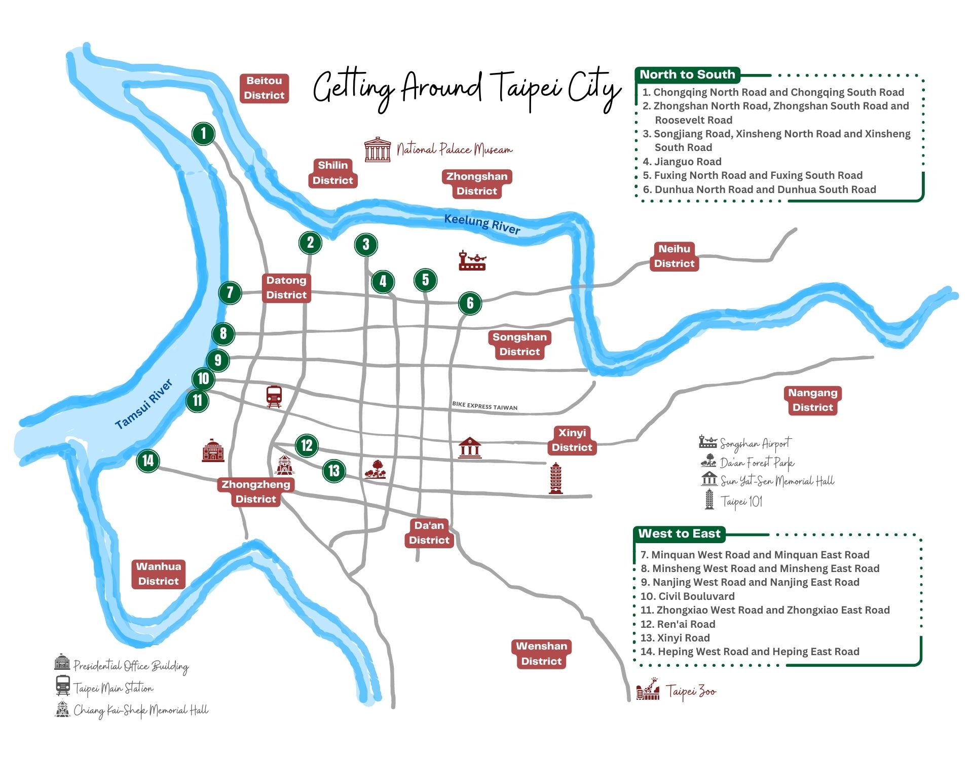
    Roads leading from North to South
    1. Chongqing North Road and Chongqing South Road 重慶北路, 重慶南路
    2. Zhongshan North Road, Zhongshan South Road and Roosevelt Road 中山北路, 中山南路, 羅斯福路
    3. Songjiang Road, Xinsheng North Road and Xinsheng South Road 新生北路, 新生南路
    4. Jianguo Road 建國路
    5. Fuxing North Road and Fuxing South Road 復興北路, 復興南路
    6. Dunhua North Road and Dunhua South Road 敦化北路, 敦化南路
    Roads leading from West to East
    1. Minquan West Road and Minquan East Road 民權西路, 民權東路
    2. Minsheng West Road and Minsheng East Road 民生西路, 民生東路
    3. Nanjing West Road and Nanjing East Road 南京西路, 南京西路
    4. Civil Bouluvard 市民大道
    5. Zhongxiao West Road and Zhongxiao East Road 忠孝西路, 忠孝東路
    6. Ren’ai Road 仁愛路
    7. Xinyi Road 信義路
    8. Heping West Road and Heping East Road 和平西路, 和平東路

    Bike-friendly Roads in Taipei City

    We have cycled and evaluated these roads to determine their level of bike-friendliness. While the conclusions may be subjective, they are not arbitrary. Our assessments are based on three main criteria and are given a rating out of five stars in total:

    • Are there designated bike lanes and can you ride on the sidewalks?
    • How busy are the outside lanes, where bikes should ride on?
    • Does the road have easy access to the Riverside Bikeways, where you can bypass city traffic altogether?

    Zhongshan North Road, Zhongshan South Road and Roosevelt Road

    Sidewalk

    Bike Lanes can be found on the sidewalks on Zhongshan North Road and Zhongshan South Road. When there is no bike lane, the sidewalks are still wide enough to cycle

    Rating: 3 out of 5.

    Outside Lane

    All bus stops are on the outside lane on Zhongshan North Road and Zhongshan South Road

    Rating: 2 out of 5.

    Access to Riverside Bikeways

    At the northern end, there is a bike ramp located approximately 20 meters further north of this parking lot, providing access to Yuanshan Park for cycling. On the southern end, the Riverside Bikeways can be reached via a ramp adjacent to Taipei City Hakka Culture Theme Park or the footbridge in this area. Please note that while the footbridge is equipped with elevators on both sides, their operation might be limited to certain hours and not available around the clock

    Rating: 4 out of 5.

    Songjiang Road, Xinsheng North Road and Xinsheng South Road

    Sidewalk

    There are bike lanes on the sidewalks but not continuously. When there is no bike lanes, the sidewalks are still ridable

    Rating: 4 out of 5.

    Outside Lane

    There are dedicated bus lanes and bus stops on the inside lanes, though some bus stops are still found on the outside lane. But bus traffic is expected to be lower in these areas

    Rating: 4 out of 5.

    Access to Riverside Bikeways

    At the northern end, you can get into the Riverside Bikeways at Lin A Tai Evacuation Gate, which is connected to Xinsheng Park, where cycling is allowed. At the southern end, the Riverside Bikeways can be accessed via Siyuan Street, adjacent to Gongguan Waterfront Plaza

    Rating: 5 out of 5.

    Fuxing North Road and Fuxing South Road

    Sidewalk

    Dedicated bike lanes on found some sections of the sidewalk on the south-bound side. Sidewalk on the north-bound side is narrower but still ridable

    Rating: 4 out of 5.

    Outside Lane

    Bus lanes on the outside lane

    Rating: 2 out of 5.

    Access to Riverside Bikeways

    Neither of these two roads has provides direct access to the Riverside Bikeways. The northern end of Fuxing North Road connects with Minzu East Road (Songshan Airport) Tunnel, where bikes not allowed. The southern end of Fuxing South Road leads to National Taiwan University

    Rating: 1 out of 5.

    Dunhua North Road and Dunhua South Road

    Sidewalk

    There is no dedicated bike lane on the sidewalks but they are still ridable

    Rating: 3 out of 5.

    Outside Lane

    Bus stops are found both on the inside lane and outside lane. Bus traffic is expected to be lower on the outside lane

    Rating: 4 out of 5.

    Access to Riverside Bikeways

    Neither of these two roads provides direct access to the Riverside Bikeways. Dunhua North Road meets Minquan East Road Section 3 and Section 4 at the northern end, while Dunhua South Road meets Keelung Road at the southern end

    Rating: 1 out of 5.

    Minquan West Road and Minquan East Road

    Sidewalk

    There is no dedicated bike lane on the sidewalks but they are so wide that cycling is not an issue

    Rating: 3 out of 5.

    Outside Lane

    Bus stops are rarely found on the outside lane as there are dedicated bus lanes in the middle of the road

    Rating: 4 out of 5.

    Access to Riverside Bikeways

    At the western end of Minquan West Road, there is a stairway with a narrow ramp that allows you to push your bike and climb up to Taipei Bridge, providing access to the Riverside Bikeways. On the eastern end of Section 5 of Minquan East Road, you can utilize the scooter lane on Minquan Bridge to reach Neihu. Additionally, there is the Tayou Water Gate available for accessing the Riverside Bikeways

    Rating: 4 out of 5.

    Nanjing West Road and Nanjing East Road

    Sidewalk

    There are continuous bike lanes on the sidewalks

    Rating: 5 out of 5.

    Outside Lane

    Bus stops are rarely found on the outside lane as there are dedicated bus lanes in the middle of the road

    Rating: 4 out of 5.

    Access to Riverside Bikeways

    Located at the western end of Nanjing West Road, you will come across a small gate providing access to the Riverside Bikeways. However, exercise caution when using this gate as there is still a road with fast-moving motorized vehicles. Alternatively, for a safer route, simply follow the signs for Cycling Route No. 1, leading you to the Dadaocheng Pier Plaza

    At the eastern end of Nanjing West Road, you will encounter Maishuaiyi Bridge, featuring a dedicated scooter lane that leads to Neihu. Although I seldom use this bridge as, personally, I prefer to use the more comfortable option of entering the Riverside Bikeways via Raohe Evacuation Gate

    Rating: 4 out of 5.

    Ren’ai Road

    Sidewalk

    The sidewalks are generally spacious enough to accommodate cycling, although not many of them have designated bike lanes marked on the ground

    Rating: 3 out of 5.

    Outside Lane

    Most buses travel on the inside lanes and their stops are conveniently located next to those lanes. There are a few bus stops found on the outside lanes. But the likelihood of encountering buses blocking your way on these lanes is relatively low compared to other roads

    Rating: 4 out of 5.

    Access to Riverside Bikeways

    Ren’ai Road provides no direct access to the Riverside Bikeways. Its eastern end meets Taipei City Hall and its western end connects with Xinyi Road Section 1 and National Taiwan University Hospital

    Rating: 1 out of 5.

    Xinyi Road

    Sidewalk

    There are continuous bike lanes on the sidewalks

    Rating: 5 out of 5.

    Outside Lane

    Most of the buses travel and stop along the inside lanes. You would rarely be blocked by buses on the outside lanes

    Rating: 4 out of 5.

    Access to Riverside Bikeways

    There is no direct access to the Riverside Bikeways. But if you head north from Xiangshan MRT Station at the eastern end, you can get to Raohe Evacuation Gate, which is an entry point to the Riverside Bikeways

    Rating: 1 out of 5.

  • Cycling Route No. 1 – 25 Taichung-Changhua-Nantou Circular Route

    Cycling Route No. 1 – 25 Taichung-Changhua-Nantou Circular Route

    Cycling Route No. 1 - 25 Taichung-Changhua-Nantou Circular Route
    Cycling Route No. 1 – 25 Taichung-Changhua-Nantou Circular Route

    Route Overview

    Total distance 65.3 km | Total ascent 776.42 m | Total descent 833.79 m

    Taichung Station (Fuxing Road) → Dazhi Road → Jiancheng Road → Provincial Highway 3 → Dali Bridge South End → Beihu Street → Dafeng Road → Caohu Road → Provincial Highway 3 → Shengfu Road → Zuci Road → Provincial Highway 3 → County Road 139 → Provincial Highway 1 → Cycling Route No. 1

    GPX Routes

    NOTE: To use the routes, please install the App on your smartphone. The App will launch and load the route automatically after you tap the above links on your smartphone’s browser. For Garmin Connect, you can then use the APP to send the route to your garmin device. If your Garmin device is not purchased in Taiwan, you will also need make sure you have the Taiwan map on your device. Here is our blog post on this topic.

    Disclaimer

    We DO NOT own the graphic and information in this post – it all came from the Taiwan Cycling Single Portal built and maintained by the Ministry of Transportation and Communications of the Taiwan Government. This website is the authoritative source of information for all those who plan to do the around-the-island trip in Taiwan. It’s very useful, but unfortunately not very user-friendly in our opinion. Therefore, what we are trying to do here is to re-organize the information in a way that we find handy and mobile-friendly.

  • Cycling Route No. 1 – 24 Gukeng-Meishan Branch Route

    Cycling Route No. 1 – 24 Gukeng-Meishan Branch Route

    Cycling Route No. 1 - 24 Gukeng-Meishan Branch Route
    Cycling Route No. 1 – 24 Gukeng-Meishan Branch Route

    Route Overview

    Total distance 36.8 km | Total ascent 398.66 m | Total descent 383.79 m

    Provincial Highway 3 (Douliu → Zhuqi) → Luming Road → County Road 159 → Zhongxiao Road → Cycling Route No. 1

    GPX Routes

    NOTE: To use the routes, please install the App on your smartphone. The App will launch and load the route automatically after you tap the above links on your smartphone’s browser. For Garmin Connect, you can then use the APP to send the route to your garmin device. If your Garmin device is not purchased in Taiwan, you will also need make sure you have the Taiwan map on your device. Here is our blog post on this topic.

    Disclaimer

    We DO NOT own the graphic and information in this post – it all came from the Taiwan Cycling Single Portal built and maintained by the Ministry of Transportation and Communications of the Taiwan Government. This website is the authoritative source of information for all those who plan to do the around-the-island trip in Taiwan. It’s very useful, but unfortunately not very user-friendly in our opinion. Therefore, what we are trying to do here is to re-organize the information in a way that we find handy and mobile-friendly.

  • Cycling Route No. 1 – 23 Kaohsiung Chaozhou Branch Route

    Cycling Route No. 1 – 23 Kaohsiung Chaozhou Branch Route

    Cycling Route No. 1 - 23 Kaohsiung Chaozhou Branch Route
    Cycling Route No. 1 – 23 Kaohsiung Chaozhou Branch Route

    Route Overview

    Total distance 60.4 km | Total ascent 189.50 m | Total descent 196.02 m

    Bo’ai 1st Road → Provincial Highway 1 (Fengshan-Chaozhou)

    GPX Routes

    NOTE: To use the routes, please install the App on your smartphone. The App will launch and load the route automatically after you tap the above links on your smartphone’s browser. For Garmin Connect, you can then use the APP to send the route to your garmin device. If your Garmin device is not purchased in Taiwan, you will also need make sure you have the Taiwan map on your device. Here is our blog post on this topic.

    Disclaimer

    We DO NOT own the graphic and information in this post – it all came from the Taiwan Cycling Single Portal built and maintained by the Ministry of Transportation and Communications of the Taiwan Government. This website is the authoritative source of information for all those who plan to do the around-the-island trip in Taiwan. It’s very useful, but unfortunately not very user-friendly in our opinion. Therefore, what we are trying to do here is to re-organize the information in a way that we find handy and mobile-friendly.

  • Cycling Route No. 1 – 22 National Museum of Marine Science & Technology Branch Route

    Cycling Route No. 1 – 22 National Museum of Marine Science & Technology Branch Route

    Cycling Route No. 1 - 22 National Museum of Marine Science & Technology Branch Route
    Cycling Route No. 1 – 22 National Museum of Marine Science & Technology Branch Route

    Route Overview

    Total distance 36.9 km | Total ascent 724.83 m | Total descent 750.23 m

    Provincial Highway 2 (National Taiwan Ocean University in Fulong) → Keelung Station – Provincial Highway 2 (Xiangfeng Street, Provincial Highway 2)

    GPX Routes

    NOTE: To use the routes, please install the App on your smartphone. The App will launch and load the route automatically after you tap the above links on your smartphone’s browser. For Garmin Connect, you can then use the APP to send the route to your garmin device. If your Garmin device is not purchased in Taiwan, you will also need make sure you have the Taiwan map on your device. Here is our blog post on this topic.

    Disclaimer

    We DO NOT own the graphic and information in this post – it all came from the Taiwan Cycling Single Portal built and maintained by the Ministry of Transportation and Communications of the Taiwan Government. This website is the authoritative source of information for all those who plan to do the around-the-island trip in Taiwan. It’s very useful, but unfortunately not very user-friendly in our opinion. Therefore, what we are trying to do here is to re-organize the information in a way that we find handy and mobile-friendly.

  • Cycling Route No. 1 – 21 Pingtung Mountain to Sea Branch Route

    Cycling Route No. 1 – 21 Pingtung Mountain to Sea Branch Route

    Cycling Route No. 1 - 21 Pingtung Mountain to Sea Branch Route
    Cycling Route No. 1 – 21 Pingtung Mountain to Sea Branch Route

    Route Overview

    Total distance 42.1 km | Total ascent 116.73 m | Total descent 242.98 m

    Provincial Highway 24 (Sandimen → Changzhi → Pingtung) → Provincial Highway 27 (Pingtung, Wandan, Xinyuan, Donggang Provincial Highway 17)

    GPX Routes

    NOTE: To use the routes, please install the App on your smartphone. The App will launch and load the route automatically after you tap the above links on your smartphone’s browser. For Garmin Connect, you can then use the APP to send the route to your garmin device. If your Garmin device is not purchased in Taiwan, you will also need make sure you have the Taiwan map on your device. Here is our blog post on this topic.

    Disclaimer

    We DO NOT own the graphic and information in this post – it all came from the Taiwan Cycling Single Portal built and maintained by the Ministry of Transportation and Communications of the Taiwan Government. This website is the authoritative source of information for all those who plan to do the around-the-island trip in Taiwan. It’s very useful, but unfortunately not very user-friendly in our opinion. Therefore, what we are trying to do here is to re-organize the information in a way that we find handy and mobile-friendly.

  • Cycling Route No. 1 – 20 Kenting Circular Route

    Cycling Route No. 1 – 20 Kenting Circular Route

    Cycling Route No. 1 - 20 Kenting Circular Route
    Cycling Route No. 1 – 20 Kenting Circular Route

    Route Overview

    Total distance 83 km | Total ascent 1585.65 m | Total descent 1860.08 m

    Provincial Highway 26 (Hengchun) → Dawan Road → Provincial Highway 26 → County Road 200A → County Road 200 → Provincial Highway 26 → County Road 199A → County Road 199

    GPX Routes

    NOTE: To use the routes, please install the App on your smartphone. The App will launch and load the route automatically after you tap the above links on your smartphone’s browser. For Garmin Connect, you can then use the APP to send the route to your garmin device. If your Garmin device is not purchased in Taiwan, you will also need make sure you have the Taiwan map on your device. Here is our blog post on this topic.

    Disclaimer

    We DO NOT own the graphic and information in this post – it all came from the Taiwan Cycling Single Portal built and maintained by the Ministry of Transportation and Communications of the Taiwan Government. This website is the authoritative source of information for all those who plan to do the around-the-island trip in Taiwan. It’s very useful, but unfortunately not very user-friendly in our opinion. Therefore, what we are trying to do here is to re-organize the information in a way that we find handy and mobile-friendly.

  • Cycling Route No. 1 – 19 Hengchun Circular Route

    Cycling Route No. 1 – 19 Hengchun Circular Route

    Cycling Route No. 1 - 19 Hengchun Circular Route
    Cycling Route No. 1 – 19 Hengchun Circular Route

    Route Overview

    Total distance 28.3 km | Total ascent 212.16 m | Total descent 233.35 m

    Checheng Provincial Highway 25 → Houwan Road → Wanli Road → Shanhai Road → Baisha Road → Daguang Road → Shawei Road → Nanguang Road → Hengchun Provincial Highway 26

    Note: While the textual description on the map is southbound from Checheng to Hengchun, the GPX is northbound from Hengchun to Checheng

    GPX Routes

    NOTE: To use the routes, please install the App on your smartphone. The App will launch and load the route automatically after you tap the above links on your smartphone’s browser. For Garmin Connect, you can then use the APP to send the route to your garmin device. If your Garmin device is not purchased in Taiwan, you will also need make sure you have the Taiwan map on your device. Here is our blog post on this topic.

    Disclaimer

    We DO NOT own the graphic and information in this post – it all came from the Taiwan Cycling Single Portal built and maintained by the Ministry of Transportation and Communications of the Taiwan Government. This website is the authoritative source of information for all those who plan to do the around-the-island trip in Taiwan. It’s very useful, but unfortunately not very user-friendly in our opinion. Therefore, what we are trying to do here is to re-organize the information in a way that we find handy and mobile-friendly.

  • Cycling Route No. 1 – 18 Kaohsiung-Pingtung Hillside Circular Route

    Cycling Route No. 1 – 18 Kaohsiung-Pingtung Hillside Circular Route

    Cycling Route No. 1 - 18 Kaohsiung-Pingtung Hillside Circular Route
    Cycling Route No. 1 – 18 Kaohsiung-Pingtung Hillside Circular Route

    Route Overview

    Total distance 117.1 km | Total ascent 1179.35 m | Total descent 1180.95 m

    Provincial Highway 28 → Fengshan Road → Xide Road → Provincial Highway 28 → Sinwei Bridge → Provincial Highway 27 → County Road 185 → Yinggu Road, Wanluan → Wande Road → Jianxing Road → Guangming Road → Jiaxing Road → Baozhong Road → County Road 187 → Provincial Highway 1 → Provincial Highway 17

    GPX Routes

    NOTE: To use the routes, please install the App on your smartphone. The App will launch and load the route automatically after you tap the above links on your smartphone’s browser. For Garmin Connect, you can then use the APP to send the route to your garmin device. If your Garmin device is not purchased in Taiwan, you will also need make sure you have the Taiwan map on your device. Here is our blog post on this topic.

    Disclaimer

    We DO NOT own the graphic and information in this post – it all came from the Taiwan Cycling Single Portal built and maintained by the Ministry of Transportation and Communications of the Taiwan Government. This website is the authoritative source of information for all those who plan to do the around-the-island trip in Taiwan. It’s very useful, but unfortunately not very user-friendly in our opinion. Therefore, what we are trying to do here is to re-organize the information in a way that we find handy and mobile-friendly.

  • Cycling Route No. 1 – 17 Moutain to Sea Branch Route

    Cycling Route No. 1 – 17 Moutain to Sea Branch Route

    Cycling Route No. 1 - 17 Moutain to Sea Branch Route
    Cycling Route No. 1 – 17 Moutain to Sea Branch Route

    Route Overview

    Total distance 20.4 km | Total ascent 116.86 m | Total descent 102.30 m

    Xilaya Boulevard → Section 1 Huanxi Road → Nanke 3rd Road → Daoye Road → Mountain-to-Sea Canal Greenway → Section 1 and Section 2 Qinghe Road, Annan District → Bridge → Kai’an 5th Road → Zheng’an Road → Section 3, Section 4, Section 5, and Section 6 Antong Road → Provincial Highway 17

    Note: While the textual description on the map is westbound from Shanhua to Annan, the GPX is eastbound from Annan to Shanhua

    GPX Routes

    NOTE: To use the routes, please install the App on your smartphone. The App will launch and load the route automatically after you tap the above links on your smartphone’s browser. For Garmin Connect, you can then use the APP to send the route to your garmin device. If your Garmin device is not purchased in Taiwan, you will also need make sure you have the Taiwan map on your device. Here is our blog post on this topic.

    Disclaimer

    We DO NOT own the graphic and information in this post – it all came from the Taiwan Cycling Single Portal built and maintained by the Ministry of Transportation and Communications of the Taiwan Government. This website is the authoritative source of information for all those who plan to do the around-the-island trip in Taiwan. It’s very useful, but unfortunately not very user-friendly in our opinion. Therefore, what we are trying to do here is to re-organize the information in a way that we find handy and mobile-friendly.